地球资源卫星50周年

地球资源卫星50周年

We’re celebrating 50 years of the Landsat satellite, the first of which launched on July 23, 1972. The latest in the series, Landsat 9, launched in September 2021. Landsat shows us Earth from space. For 50 years, the mission has collected data on the forests, farms, urban areas and freshwater of our home planet, generating the longest continuous record of its kind. Decision makers from across the globe use freely available Landsat data to better understand environmental change, manage agricultural practices, allocate scarce water resources, respond to natural disasters and more. This natural color image of Eleuthera Island, the Bahamas, was taken by Landsat 9 on January 18, 2022. Between Landsat 8 and Landsat 9, the Landsat program delivers complete coverage of the Earth’s surface…

从国际空间站看太平洋

从国际空间站看太平洋

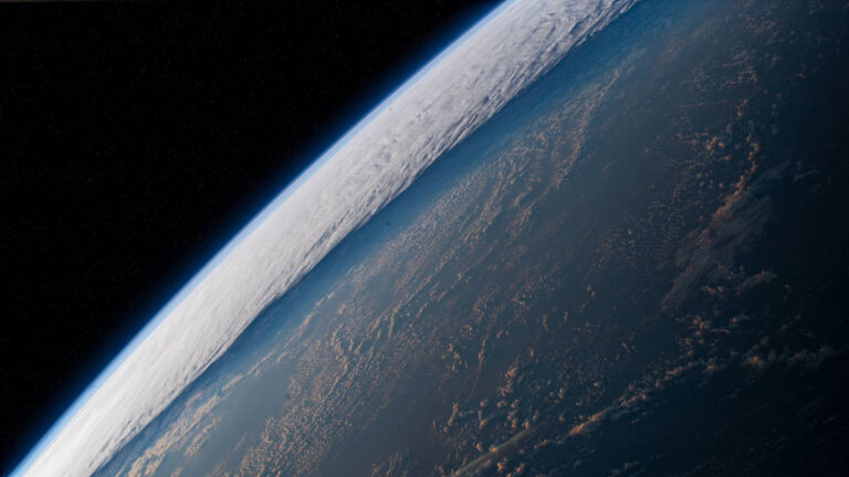
The International Space Station orbits into a dawn 261 miles above a cloudy Pacific Ocean in this image from April 2022. Not only does the station crew snap beauty shots of the planet we call home, the crew also conducts a variety of Earth and space science, including observations of the world’s oceans. NASA also has a variety of Earth-observing missions and even studies ocean worlds throughout our solar system. #WorldOceansDay Resources Search Space Station Research Learn More About NASA’s Earth-Observing Missions Why Study the Oceans? Ocean Worlds: Water in the Solar System and Beyond 这张照片拍摄于2022年4月,国际空间站在多云的太平洋上空261英里的轨道上进入黎明。 空间站工作人员不仅拍摄我们称之为家的星球的美丽照片,而且工作人员还进行各种地球和太空科学,包括对世界海洋的观测。 NASA也有各种各样的地球观测任务,甚至研究太阳系中的海洋世界。 #WorldOceansDay 资源 搜索空间站研究 了解更多有关NASA地球观测任务的信息 为什么要研究海洋? 海洋世界:太阳系内外的水

关于NASA的新矿物尘埃探测器,你需要知道的5件事

关于NASA的新矿物尘埃探测器,你需要知道的5件事

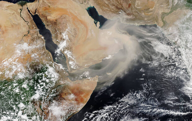
在这张由Suomi NPP卫星于2018年7月拍摄的图像中,阿拉伯半岛上空盘旋着尘埃。美NASA即将进行的地球表面矿物尘埃源调查(EMIT)将帮助科学家们更好地了解空气中的尘埃在加热和冷却大气中的作用。 影像来源:NASA Earth Observatory 名为EMIT的地球表面矿物尘埃源调查将分析从干燥地区穿过大气层的尘埃,以了解其对地球的影响。 每年,强风将来自地球沙漠和其他干旱地区的10亿吨(相当于10000艘航空母舰的重量)矿物尘埃带入大气层。虽然科学家知道尘埃会影响环境和气候,但他们没有足够的数据来详细确定这些影响是什么,或者将来可能是什么——至少现在还没有。 6月9日,NASA向国际空间站发射的地球表面矿物尘埃源调查(EMIT)仪器,将有助于填补这些知识空白。EMIT最先进的成像光谱仪由该机构位于南加州的喷气推进实验室开发,将在一年内收集全球超过10亿个尘埃源成分测量数据,从而将使科学家们对灰尘在整个地球系统中的影响的理解大大提高。 以下是关于EMIT需要了解的5件事: 1、它将识别来自地球干旱地区的矿物尘埃的组成。 沙漠地区产生了大部分进入大气的矿物尘埃。此外,这些地方非常偏远,科学家们很难在这些广阔的地区手工收集土壤和尘埃样本。 从其位于空间站的位置,EMIT将绘制出世界矿物尘埃源地区的地图。成像光谱仪还将首次提供全球尘埃源的颜色和组成信息。这些数据将有助于科学家了解每个地区的主要尘埃种类,并进一步了解尘埃对当今和未来气候和地球系统的影响。 利用JPL开发的图像光谱仪技术,EMIT将绘制出地球产尘区矿物的表面组成图,帮助气候科学家更好地了解空气中尘埃粒子在加热和冷却地球大气层中的影响。 影像来源:NASA/JPL-Caltech 2、它将阐明矿物尘埃是加热还是冷却地球。 目前,科学家们不知道矿物尘埃是否会对地球产生累积的加热或冷却效应。那是因为大气中的尘埃颗粒具有不同的特性。例如,一些颗粒可能是深红色的,而另一些可能是白色的。 尘埃颗粒的颜色非常重要,,因为它决定了尘埃是像深色矿物那样吸收太阳能量,还是像浅色矿物那样反射太阳能量。如果更多的尘埃吸收太阳的能量太阳的能量,那么尘埃将使地球变暖,反之亦然。 EMIT将提供一个详细的图片,说明有多少尘埃来自深色矿物和浅色矿物。这一信息将使科学家能够确定尘埃对地球的整体、区域和局部是升温还是降温。 3、它将帮助科学家了解尘埃如何影响不同的地球进程 NASA和JPL的官员监督EMIT科学仪器的振动测试,包括其望远镜和成像光谱仪。 影像来源:NASA/JPL-Caltech 矿物尘埃颗粒的颜色各不相同,因为它们由不同的物质组成。例如,深红色矿物尘埃的颜色来自铁。尘埃粒子的组成影响着它们与地球许多自然过程的相互作用。 例如,矿物尘埃在云的形成和大气化学中起着重要作用。当矿物尘埃沉积在海洋或森林中时,它可以为生长提供养分,就像肥料一样。当它落在雪或冰上时,尘埃加速融化,导致更多的水流失。对人类来说,矿物尘埃吸入后会对健康造成危害。 EMIT将收集10种重要尘埃的信息,包括含有氧化铁、粘土和碳酸盐的尘埃。有了这些数据,科学家将能够准确评估矿物尘埃对不同生态系统和过程的影响。 4、它的数据将提高气候模型的准确性。 由于缺乏更具体的数据,科学家们目前在气候模型中把矿物尘埃的特征描述为黄色——黑暗和光明的一般平均值。正因为如此,矿物尘埃可能对气候的影响——以及气候可能对矿物尘埃的影响——并没有在计算机模型中得到很好的体现。 EMIT收集的颜色和组成信息将改变这一点。当纳入仪器的数据后,气候模型的准确性有望提高。 5、它将帮助科学家预测未来的气候情景将如何影响我们大气中尘埃的类型和数量。 随着全球气温的上升,干旱地区可能会变得更加干旱,可能导致更大(和更多尘埃)的沙漠。这种情况会在多大程度上发生取决于几个因素,包括气温上升多少,土地利用如何变化,以及降雨趋势如何变化。 通过将EMIT的全球尘埃源组成数据纳入模型和预测,科学家将更好地了解干旱地区的尘埃数量和组成在不同气候和土地利用情景下可能发生的变化。他们还将更好地了解这些变化如何影响未来的气候。 关于任务的更多信息 NASA喷气推进实验室正在开发EMIT,该实验室由加利福尼亚州帕萨迪纳的加州理工学院为该机构管理。它将从佛罗里达州的肯尼迪航天中心发射到国际空间站,这是SpaceX公司为NASA执行的第25次商业补给服务任务。一旦EMIT开始运行,其数据将被交付给NASA陆地过程分布式活动存档中心(DAAC),供其他研究人员和公众使用。 如欲了解有关该任务的更多信息,请访问: https://earth.jpl.nasa.gov/emit/ 参考来源: https://www.nasa.gov/feature/jpl/5-things-to-know-about-nasa-s-new-mineral-dust-detector

2022年飓风季节开始

2022年飓风季节开始

Hurricanes are the most powerful weather event on Earth. The 2022 Atlantic hurricane season extends from June 1 to November 30. Faster than a cheetah, the fastest animal on land, hurricanes produce winds of 74 miles an hour (119 kilometers per hour) or more. In this image from 2021, the crew aboard the International Space Station snapped this image of Hurricane Sam as it churned in the Atlantic Ocean while the station orbited 259 miles above Trinidad and Tobago. Image Credit: NASA 飓风是地球上最强大的天气现象。2022年大西洋飓风季从6月1日持续到11月30日。 飓风的风速比陆地上最快的动物猎豹还要快,达到每小时74英里(每小时119公里)甚至更高。 在这张2021年的照片中,国际空间站的机组人员在特立尼达和多巴哥上空259英里的轨道上拍摄了飓风山姆在大西洋翻腾的照片。 图片来源:美国国家航空航天局

轨道上的地球:NOAA首次发布GOES-18卫星图像

轨道上的地球:NOAA首次发布GOES-18卫星图像

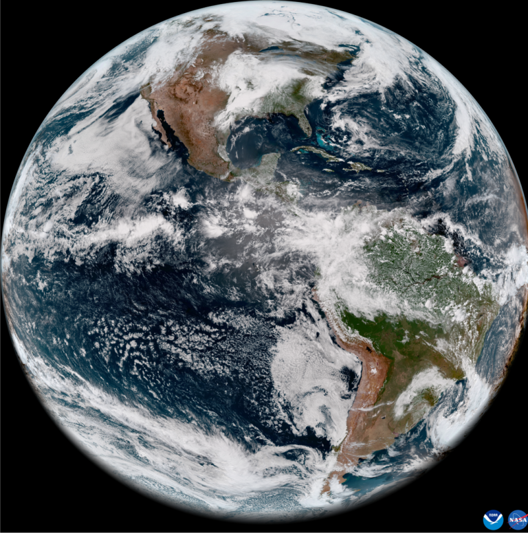
On May 11, 2022, the National Oceanic and Atmospheric Administration, or NOAA, shared the first images of the Western Hemisphere from its Geostationary Operational Environmental Satellite-T (GOES-T). Later designated GOES-18, the satellite’s Advanced Baseline Imager (ABI) instrument recently captured stunning views of Earth. Launched by NASA on March 1, GOES-18 lifted off at 4:38 p.m. EST from Cape Canaveral Space Force Station’s Space Launch Complex 41 in Florida. The ABI views Earth with 16 different channels, each measuring energy at different wavelengths along the electromagnetic spectrum to obtain information about Earth’s atmosphere, land, and ocean. Learn more: GOES Overview and History Image Credit: NOAA 2022年5月11日,美国国家海洋和大气管理局(简称NOAA)分享了其地球同步运行环境卫星-T(GOES-T)拍摄的第一张西半球图像。该卫星的高级基线成像仪(ABI)仪器后来被命名为GOES-18,它最近拍摄到了地球的壮丽景色。 GOES-18由NASA于3月1日发射,于美国东部时间下午4:38从佛罗里达州卡纳维拉尔角空间站的41号空间发射场发射升空。ABI用16个不同的通道观察地球,每个通道测量电磁波谱中不同波长的能量,以获取有关地球大气、陆地和海洋的信息。 了解更多:GOES的概况和历史 影像来源:NOAA

横跨地球的日出

横跨地球的日出

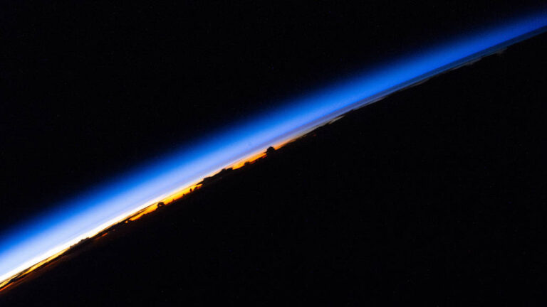
The crew aboard the International Space Station has a window on Planet Earth. In this image an orbital sunrise beams across Earth’s horizon revealing silhouetted clouds above the South China Sea. Every 24 hours, the space station makes 16 orbits of Earth, traveling through 16 sunrises and sunsets. Learn More International Space Station Facts and Figures #EarthDay Image Credit: NASA 国际空间站上的工作人员有一扇观察地球的窗口。在这张图片中,轨道上的日出穿过地球的地平线,露出中国南海上空的剪影云。 空间站每24小时绕地球运行16圈,经历16次日出和日落。 了解更多 国际空间站事实和数字 #EarthDay 图片来源:NASA

暮光时分的地球

暮光时分的地球

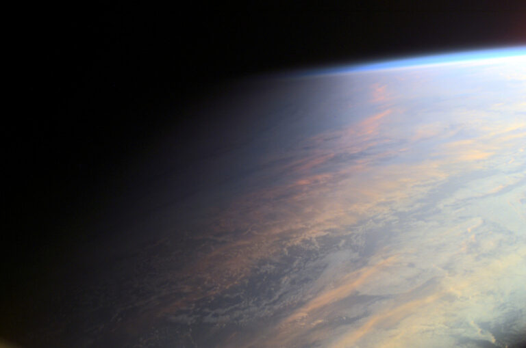
2022年4月22日 Planet Earth at Twilight Image Credit: ISS Expedition 2 Crew, Gateway to Astronaut Photography of Earth, NASA Explanation: No sudden, sharp boundary marks the passage of day into night in this gorgeous view of ocean and clouds over our fair planet Earth. Instead, the shadow line or terminator is diffuse and shows the gradual transition to darkness we experience as twilight. With the Sun illuminating the scene from the right, the cloud tops reflect gently reddened sunlight filtered through the dusty troposphere, the lowest layer of the planet’s nurturing atmosphere. A clear high altitude layer, visible along the dayside’s upper edge, scatters blue sunlight and fades into the blackness of space. This picture was taken in June of 2001 from the International Space Station…

地球上方的航天飞机

地球上方的航天飞机

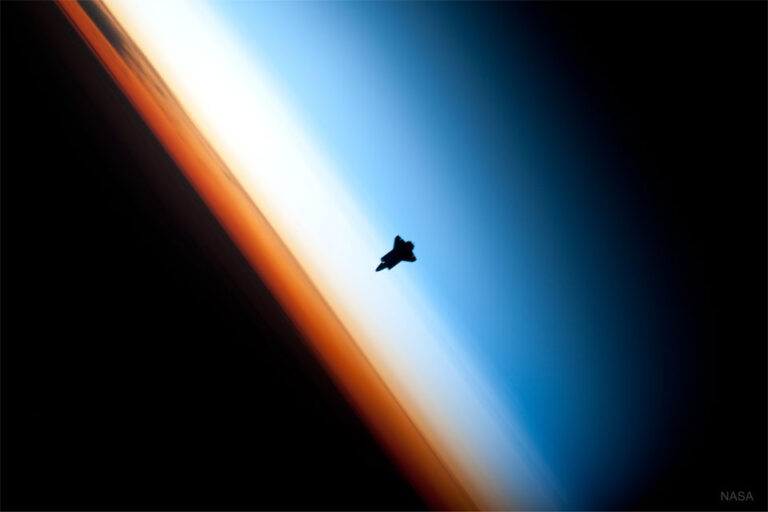
2022年4月17日 Shuttle Over Earth Image Credit: NASA, Expedition 22 Crew Explanation: What’s that approaching? Astronauts on board the International Space Station in 2010 first saw it far in the distance. Soon it enlarged to become a dark silhouette. As it came even closer, the silhouette appeared to be a spaceship. Finally, the object revealed itself to be the Space Shuttle Endeavour, and it soon docked as expected with the Earth-orbiting space station. Pictured here, Endeavour was imaged near Earth’s horizon as it approached, where several layers of the Earth’s atmosphere were visible. Directly behind the shuttle is the mesosphere, which appears blue. The atmospheric layer that appears white is the stratosphere, while the orange layer is Earth’s Troposphere. Together, these thin layers of air —…