夜空和国家公园

夜空和国家公园

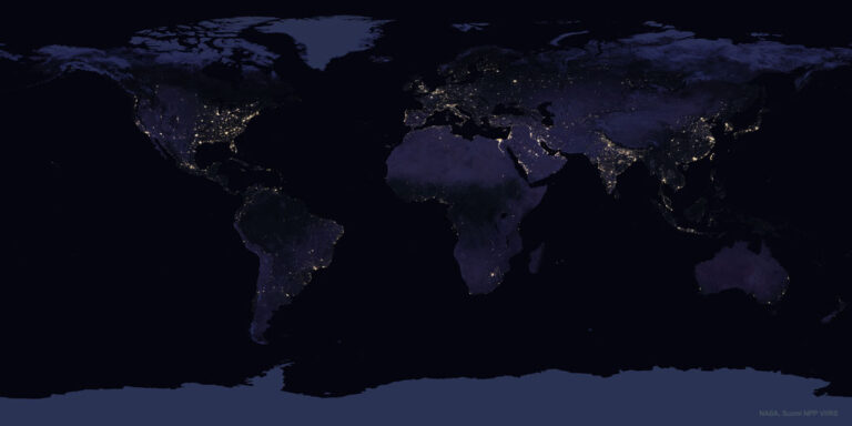
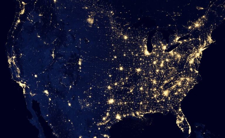
NASA and the National Park Service worked together to create a web-based tool that helps park managers better understand the impact of outdoor lighting and noise on animal species in national parks. The website allows park managers to choose a time period, such as the spring or winter seasons, and then zoom into a particular park to see sound and nighttime lights data and determine which animal species might be at risk from those sensory stimuli. Observations from space, such as nighttime light data from the NASA/NOAA Suomi NPP satellite used to produce this United States map, help to better gauge the impact of outdoor lighting on animal species in national parks. April 16-24, 2022, is National Park Week. Parks across the country are hosting…

日本的艺予诸岛

日本的艺予诸岛

Japan’s Geiyo Archipelago, in the Seito Inland Sea, was once home to pirates. From the 9th to the 16th centuries, the pirates dominated the Inland Sea and terrorized the coasts of East Asia. Until the Shimanami Kaido (Inland Wave Sea Road) was completed in 1999, the Geiyo Islands were a remote region, accessible only by boat. This ASTER image was acquired Aug. 19, 2010. With its 14 spectral bands from the visible to the thermal infrared wavelength region and its high spatial resolution of about 50 to 300 feet (15 to 90 meters), ASTER images Earth to map and monitor the changing surface of our planet. ASTER is one of five Earth-observing instruments launched Dec. 18, 1999, on Terra. The instrument was built by Japan’s…

融化的永久冻土可能会将微生物和化学物质溶解到环境中

融化的永久冻土可能会将微生物和化学物质溶解到环境中

永久冻土的融化会导致土地消失,如图所示,阿拉斯加德鲁角沿岸的部分海岸断崖已塌陷入海。 影像来源:本杰明·琼斯,美国地质勘探局 为了更全面地了解气候变化是如何影响地球上的冰冻地区,科学家们正在结合从空气、陆地和太空收集的数据。 被困在地球永久冻土层(至少会冻结两年的土地)中的是无数的温室气体、微生物和化学物质,包括现在被禁止的杀虫剂DDT。随着地球变暖,永久冻土正在以越来越快的速度融化,科学家们在试图确定永久冻土融化的潜在影响时面临着许多不确定性。 今年早些时候发表在《自然评论地球与环境》杂志上的一篇论文着眼于永久冻土研究的现状。除了强调关于永久冻土融化的结论外,这篇论文还关注了研究人员正在寻求如何解决围绕它的问题。 基础设施已经受到影响:永久冻土融化导致巨大的天坑、电线杆坍塌、道路和跑道受损以及树木倒塌。很难看清是什么被困在由土壤、冰和死有机物组成的永久冻土里。研究关注了DDT和微生物等化学物质如何从融化的永久冻土中释放出来,其中一些已经被冻结了数千年,甚至数百万年。 然后是融化的永久冻土对地球碳的影响:仅北极永久冻土就含有约17,000亿吨碳,包括甲烷和二氧化碳。这大约是2019年世界化石燃料排放量的51倍。冻结在永久冻土中的植物物质不会腐烂,但当永久冻土融化时,死去的植物材料中的微生物开始分解物质,将碳释放到大气中。 “目前的模型预测,未来一百年内,我们将看到一波碳从永久冻土释放到大气中,可能更早。”位于南加州的美国宇航局喷气推进实验室的气候研究员、该论文的主要作者金伯利·米纳说。但关键细节——如碳释放的数量、具体来源和持续时间——仍不清楚。 最坏的情况是,如果所有的二氧化碳和甲烷都在很短的时间(比如几年)内释放。另一种情况是碳将缓慢的释放。有了更多的信息,科学家们希望更好地了解这两种情况发生的可能性。 尽管这篇综述文章发现地球极地地区变暖最快,但关于增加的碳排放会如何导致北极地区更干燥或更潮湿的环境,目前尚无定论。更可以肯定的是,北极和南极的变化将波及低纬度地区。地球的极地有助于稳定地球的气候。它们有助于推动热量从赤道向高纬度地区转移,从而形成大气环流,为急流和其他洋流提供动力。一个温暖的、没有永久冻土的北极可能会对地球的天气和气候产生不可估量的影响。 综合方法 为了了解永久冻土融化的影响,越来越多的科学家正转向从地面、空中和太空进行的综合地球观测——这是论文中概述的技术。每种方法都有其优缺点。 例如,地面观测可以精确监测局部区域的变化,而机载和天基测量可以覆盖广阔的区域。地面和空中观测侧重于收集它们的具体时间,而卫星则不断地监测地球——尽管它们可能受到云层覆盖、一天中的时间或卫星任务最终结束等因素的限制。 他们希望通过结合多个平台进行观测,可以帮助科学家更全面地了解两极的变化,因为那里的永久冻土层融化得最快。 米诺正在与地面上的同事一起研究冻结在永久冻土中的微生物的特征,而其他人则在使用机载仪器测量甲烷等温室气体的排放。此外,机载和卫星任务可以帮助确定永久冻土冻土地区的排放热点。 还有一些卫星任务正在筹备中,这些任务将提供更高分辨率的碳排放数据。ESA(欧洲航天局)哥白尼高光谱成像任务将绘制土地覆盖变化图,并帮助监测土壤特性和水质。NASA的表面生物学和地质学(SBG)任务还将使用基于卫星的成像光谱来收集研究领域的数据,包括植物及其健康;与山体滑坡和火山爆发等事件相关的土地变化;以及雪和冰的积累、融化和亮度(与反射回太空的热量有关)。 SBG是NASA地球系统天文台未来几项地球科学任务之一的重点领域。这些卫星将一起提供从地球表面到大气层的三维整体视图。他们将提供有关气候变化、自然灾害、极端风暴、水资源可用性和农业等主题的信息。 ““每个人都在以最快的速度比赛,以了解极地发生了什么。”米诺说。“我们了解得越多,我们对未来的准备就越充分。” 参考来源: https://www.nasa.gov/feature/jpl/thawing-permafrost-could-leach-microbes-chemicals-into-environment

36亿年的彩色蜡笔

36亿年的彩色蜡笔

The Pilbara in northwestern Australia exposes some of the oldest rocks on Earth, over 3.6 billion years old. The iron-rich rocks formed before the presence of atmospheric oxygen, and life itself. Found upon these rocks are 3.45 billion-year-old fossil stromatolites, colonies of microbial cyanobacteria. The image, acquired in October 2004, is a composite of ASTER bands 4-2-1 displayed in RGB. With its 14 spectral bands from the visible to the thermal infrared wavelength region and its high spatial resolution of about 50 to 300 feet (15 to 90 meters), ASTER images Earth to map and monitor the changing surface of our planet and is one of five Earth-observing instruments launched Dec. 18, 1999, on the Terra satellite. The instrument was built by Japan’s Ministry of…

发射探测器以研究脉动极光

发射探测器以研究脉动极光

The LAMP mission, short for Loss through Auroral Microburst Pulsations, launched on Saturday, Marc 5, 2022, aboard a Black Brant IX suborbital sounding rocket. The mission will study an often overlooked kind of aurora, called a pulsating aurora, and test a theory on what causes them. Like all aurora, a pulsating aurora is set alight by electrons (and occasionally protons) from near-Earth space. These electrons plunge into our atmosphere and collide with atoms and molecules, causing them to glow in their distinctive colors – red and green by oxygen, blue by nitrogen – as they release their excess energy. Image Credit: NASA LAMP任务是极光微爆发脉动损失的简称,于2022年3月5日星期六搭载Black Brant IX亚轨道探空火箭发射升空。这项任务将研究一种经常被忽视的极光,称为脉动极光,并测试其成因的理论。 像所有的极光一样,脉动极光是由近地空间的电子(偶尔也有质子)点燃。这些电子进入我们的大气层,与原子和分子碰撞,使它们在释放多余能量时发出独特的颜色——氧气发出红色和绿色,氮气发出蓝色。 图片来源:NASA

地球同步运行环境卫星-T发射升空

地球同步运行环境卫星-T发射升空

A United Launch Alliance Atlas V 541 rocket, carrying the National Oceanic and Atmospheric Administration’s (NOAA) Geostationary Operational Environmental Satellite-T (GOES-T), soars upward after lifting off from Space Launch Complex 41 at Cape Canaveral Space Force Station in Florida on March 1, 2022. Liftoff was at 4:38 p.m. EST. GOES-T is the third satellite in the GOES-R series that will continue to help meteorologists observe and predict local weather events that affect public safety. GOES-T will be renamed GOES-18 once it reaches geostationary orbit. GOES-18 will go into operational service as GOES West to provide critical data for the U.S. West Coast, Alaska, Hawaii, Mexico, Central America, and the Pacific Ocean. Image Credit: NASA/Kim Shiflett 2022年3月1日,美国联合发射联盟的阿特拉斯-5型 541运载火箭搭载着美国国家海洋和大气管理局(NOAA)的地球同步运行环境卫星-T(GOES-T,从佛罗里达州卡纳维拉尔角太空部队站的41号太空发射综合体发射升空。GOES-T是GOES-R系列中的第三颗卫星,将继续帮助气象学家观察和预测影响公共安全的当地天气事件。一旦进入地球同步轨道,GOES-T将被命名为GOES-18。GOES-18将作为GOES West投入运行服务,为美国西海岸、阿拉斯加、夏威夷、墨西哥、中美洲和太平洋提供关键数据。 图片来源:NASA/Kim Shiflett

地升1号:复刻的历史性影像

地升1号:复刻的历史性影像

2022年2月27日 Earthrise 1: Historic Image Remastered Image Credit: NASA, Apollo 8 Crew, Bill Anders; Processing and License: Jim Weigang Explanation: “Oh my God! Look at that picture over there! Here’s the Earth coming up. Wow is that pretty!” Soon after that pronouncement, 50 years ago today, one of the most famous images ever taken was snapped from the orbit of the Moon. Now known as “Earthrise”, the iconic image shows the Earth rising above the limb of the Moon, as taken by the crew of Apollo 8. But the well-known Earthrise image was actually the second image taken of the Earth rising above the lunar limb — it was just the first in color. With modern digital technology, however, the real first Earthrise image —…

夜晚的地球

夜晚的地球

2022年2月13日 Earth at Night Image Credit: NASA, Suomi NPP VIIRS; Data: Miguel Román (NASA GSFC); Processing: Joshua Stevens Explanation: This is what the Earth looks like at night. Can you find your favorite country or city? Surprisingly, city lights make this task quite possible. Human-made lights highlight particularly developed or populated areas of the Earth’s surface, including the seaboards of Europe, the eastern United States, and Japan. Many large cities are located near rivers or oceans so that they can exchange goods cheaply by boat. Particularly dark areas include the central parts of South America, Africa, Asia, and Australia. The featured image, nicknamed Black Marble, is actually a composite of hundreds of pictures remade in 2016 from data taken by the orbiting Suomi NPP satellite….