日全食时的地球
地球的一部分被蓝色的海洋和白色的云所描绘。左上角是深空黑暗背景。地球上有一个明显的大黑点。有关更多详细信息,请参阅说明。
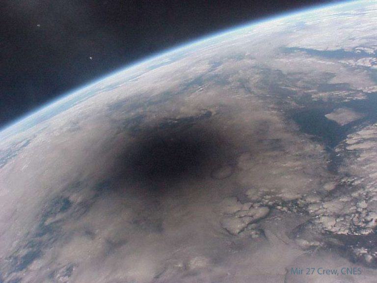
地球的一部分被蓝色的海洋和白色的云所描绘。左上角是深空黑暗背景。地球上有一个明显的大黑点。有关更多详细信息,请参阅说明。

三月份的天空会发生什么?与月亮亲密配对,水星现身,微弱的月食,还有机会看到彗星。

二月份的天空会发生什么?金星和火星是一对,木星和月球是对方的情人,观测M81,又名“波德星系”。

2024年1月24日 Earth and Moon from Beyond Image Credit: NASA, Artemis I; Processing: Andy Saunders Explanation: What do the Earth and Moon look like from beyond the Moon? Although frequently photographed together, the familiar duo was captured with this unusual perspective in late 2022 by the robotic Orion spacecraft of NASA‘s Artemis I mission as it looped around Earth’s most massive satellite and looked back toward its home world. Since our Earth is about four times the diameter of the Moon, the satellite’s seemingly large size was caused by the capsule being closer to the smaller body. Artemis II, the next launch in NASA’s Artemis series, is currently scheduled to take people around the Moon in 2025, while Artemis III is planned to return humans to…

2023年11月30日 Artemis 1: Flight Day 13 Image Credit: NASA, Artemis I Explanation: On flight day 13 (November 28, 2022) of the Artemis I mission, the Orion spacecraft reached its maximum distance from its home world. Over 430,000 kilometers from Earth in a distant retrograde orbit, Orion surpassed the record for most distant spacecraft designed to carry humans. That record was previously set in 1970 during the Apollo 13 mission to the Moon. Both Earth and Moon are in the same field of view in this video frame from Orion on Artemis I mission flight day 13. The planet and its large natural satellite even appear about the same apparent size from the uncrewed spacecraft’s perspective. Tomorrow’s picture: galaxy rise 阿尔忒弥斯1号:任务的第13天 影像提供: NASA, Artemis I 说明:…

2023年11月18日 Planet Earth from Orion Image Credit: NASA, Artemis I Explanation: One year ago a Space Launch System rocket left planet Earth on November 16, 2022 at 1:47am EST carrying the Orion spacecraft on the Artemis I mission, the first integrated test of NASA’s deep space exploration systems. Over an hour after liftoff from Kennedy Space Center’s historic Launch Complex 39B, one of Orion’s external video cameras captured this view of its new perspective from space. In the foreground are Orion’s Orbital Maneuvering System engine and auxillary engines, at the bottom of the European Service Module. Beyond one of the module’s 7-meter long extended solar array wings lies the spacecraft’s beautiful home world. Making close flybys of the lunar surface and reaching a retrograde orbit…

NASA’s Earth Polychromatic Imaging Camera aboard the Deep Space Climate Observatory (DSCOVR) captured the lunar shadow during the Oct. 14 annular solar eclipse. The sensor provides frequent global views of Earth from its position at Lagrange Point 1, a gravitationally stable point between the Sun and Earth about 1.5 million kilometers from Earth. DSCOVR is a space weather station that monitors changes in the solar wind, providing space weather alerts and forecasts for geomagnetic storms that could disrupt power grids, satellites, telecommunications, aviation and GPS. Image Credit: NASA 10月14日日环食期间,NASA搭载在深空气候观测站(DSCOVR)上的地球多色成像相机拍摄到了月影。该传感器从拉格朗日点L1的位置提供地球的频繁全球视图,拉格朗日点L1是太阳和地球之间的引力稳定点,距离地球约150万公里。 DSCOVR是一个太空气象站,监测太阳风的变化,为可能破坏电网、卫星、电信、航空和GPS的地磁风暴提供空间天气警报和预报。 影像来源:NASA

Expedition 69 Flight Engineer Jasmin Moghbeli captured this image of New Zealand, with its snow-capped Southern Alps mountain range pictured between the partly cloudy Tasman Sea and Pacific Ocean, on Sept. 12, 2023. At the bottom right of the image, one of the International Space Station’s roll-out solar arrays is seen as the station orbited 271 miles above the island nation. Since the station became operational in November 2000, crew members have produced hundreds of thousands of images of the land, oceans, and atmosphere of Earth through Crew Earth Observations. These photographs record how the planet changes over time due to human activity and natural events. Image Credit: NASA / Jasmin Moghbeli 2023年9月12日,第69号远征队的飞行工程师贾斯敏·莫贝利拍摄了这张新西兰的照片,照片中白雪覆盖的南阿尔卑斯山脉位于部分多云的塔斯曼海和太平洋之间。在图片的右下角,国际空间站的一个太阳能电池阵列正在这个岛国上空271英里的轨道上运行。 自从国际空间站于2000年11月投入使用以来,工作人员已经通过对地观测拍摄了数十万张地球陆地、海洋和大气的照片。这些照片记录了由于人类活动和自然事件,地球是如何随着时间而变化。 影像来源:NASA / Jasmin Moghbeli

A snowy egret, identifiable by its slender black bill, black legs and yellow feet, marches through a pond near NASA’s Kennedy Space Center, looking for food in this image from March 29, 2007. This species inhabits salt marshes, ponds, rice field and shallow coastal bays from Maine to southern South America. They are also found in northern California, Texas, and Oklahoma. Kennedy shares a boundary with the Merritt Island National Wildlife Refuge, which surrounds it; more than 330 native and migratory bird species live there. Image credit: NASA/Ken Thornsley 在这张2007年3月29日拍摄的照片中,一只雪白的白鹭,从它细长的黑色喙,黑色的腿和黄色的脚可以辨认出来,它正在寻找食物。该物种栖息于从缅因州到南美南部的盐沼,池塘,稻田和浅海岸海湾。加州北部、德克萨斯州和俄克拉何马州也有它们的身影。肯尼迪与环绕着它的梅里特岛国家野生动物保护区接壤;超过330种本地和候鸟生活在那里。 图片来源:NASA/Ken Thornsley

据NASA戈达德太空研究所(GISS)的科学家称,2023年7月是全球气温记录中最热的一个月。