从国际空间站俯瞰拉古纳圣拉斐尔国家公园
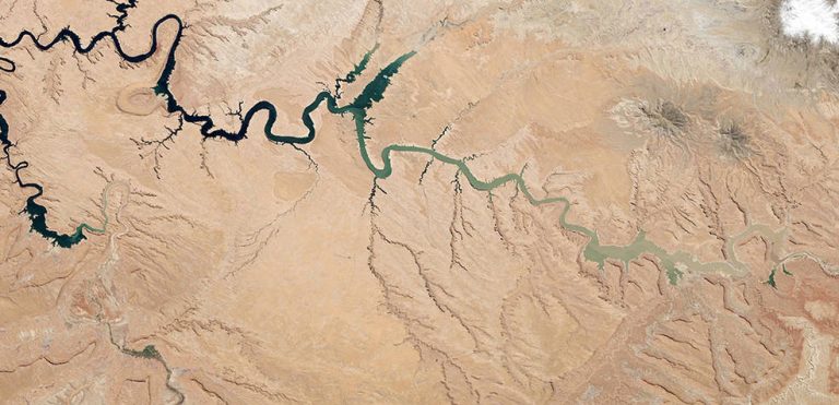
拉古纳圣拉斐尔国家公园以其众多河流和巴塔哥尼亚北部最大的冰川之一而闻名,这张照片拍摄于2023年5月9日,当时空间站在智利上空268英里的轨道上运行。

拉古纳圣拉斐尔国家公园以其众多河流和巴塔哥尼亚北部最大的冰川之一而闻名,这张照片拍摄于2023年5月9日,当时空间站在智利上空268英里的轨道上运行。
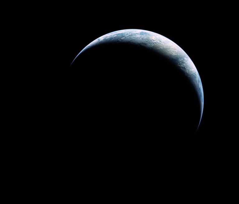
2023年5月13日 Apollo 17: The Crescent Earth Image Credit: Apollo 17, NASA; Restoration – Toby Ord Explanation: Our fair planet sports a curved, sunlit crescent against the black backdrop of space in this stunning photograph. From the unfamiliar perspective, the Earth is small and, like a telescopic image of a distant planet, the entire horizon is completely within the field of view. Enjoyed by crews on board the International Space Station, only much closer views of the planet are possible from low Earth orbit. Orbiting the planet once every 90 minutes, a spectacle of clouds, oceans, and continents scrolls beneath them with the partial arc of the planet’s edge in the distance. But this digitally restored image presents a view so far only achieved by 24…
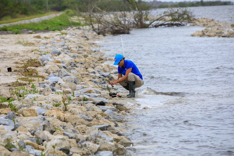
A team member from the Environmental Management Branch at NASA’s Kennedy Space Center works to remove a mangrove seedling deposited by tropical winds on the shoreline of KARS Park at Kennedy in this image from April 12, 2023. This spring, workers in the area replaced sand and finished an offshore wave break. The mangroves will be repotted and held in nearby surface water protected from wind, waves, and ongoing maintenance activities until they can be replanted along the shoreline later. With its 140,000 acres located along the Atlantic coastline and within the Indian River Lagoon estuary, Kennedy has long taken measures to ensure its shorelines remain resilient. Mangroves are one of the greatest allies against erosion, as their root structure protects the shoreline in addition…
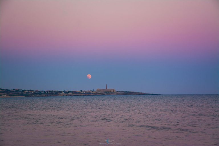
2023年5月9日 Shadows of Earth Image Credit & Copyright: Marcella Giulia Pace Explanation: Can you find two Earth shadows in today’s image? It’s a bit tricky. To find the first shadow, observe that the top part of the atmosphere appears pink and the lower part appears blue. This is because the top half is exposed to direct sunlight, while the lower part is not. The purple area in between is known as the Belt of Venus, even though Venus can only appear on the other side of the sky, near the Sun. The blue color of the lower atmosphere is caused by the Earth blocking sunlight, creating Earth shadow number 1. Now, where is the second Earth shadow? Take a look at the Moon. Do you…
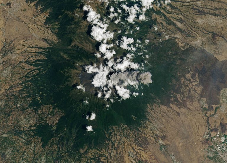
Popocatépetl, one of Mexico’s most active volcanoes, has been erupting since 2005. On April 14, 2023, when this image was acquired by Landsat 8, monitoring systems detected water vapor, volcanic gases, and ash coming from the volcano. Plumes rose as high as 4.5 miles (7.3 kilometers). Learn more about Popocatépetl. Image Credit: NASA/Lauren Dauphin; USGS 波波卡特佩特尔火山是墨西哥最活跃的火山之一,自2005年以来一直在喷发。2023年4月14日,当地球资源卫星8号获取这张图像时,监测系统检测到了来自火山的水蒸气、火山气体和火山灰。羽流高达4.5英里(7.3公里)。 了解关于波波卡特佩特火山的更多信息。 影像来源:NASA/Lauren Dauphin; USGS

5月份的天空会发生什么?月球与行星的合影,我们到达了“金星的顶峰”,以及南半球的天空有什么不同呢?

Former NASA Administrator Charlie Bolden speaks with local students during an Earth Day event, Thursday, April 20, 2023, at Union Station in Washington. The agency’s Earth Day exhibits are a free, public part of yearly celebrations; visitors can participate in hands-on activities and learn about the many ways NASA conducts Earth science. Image Credit: NASA/Keegan Barber 2023年4月20日,星期四,在华盛顿联合车站举行的地球日活动中,前NASA局长查理·博尔登与当地学生交谈。该机构的地球日展览是一个免费的、公共年度庆祝活动的一部分;参观者可以参与实践活动,了解NASA开展地球科学的多种方式。 图片来源: NASA/Keegan Barber
OPERA可以整合来自多颗卫星的数据,帮助政府机构、灾难应急人员和公众获取关于自然和人类对土地影响的数据。
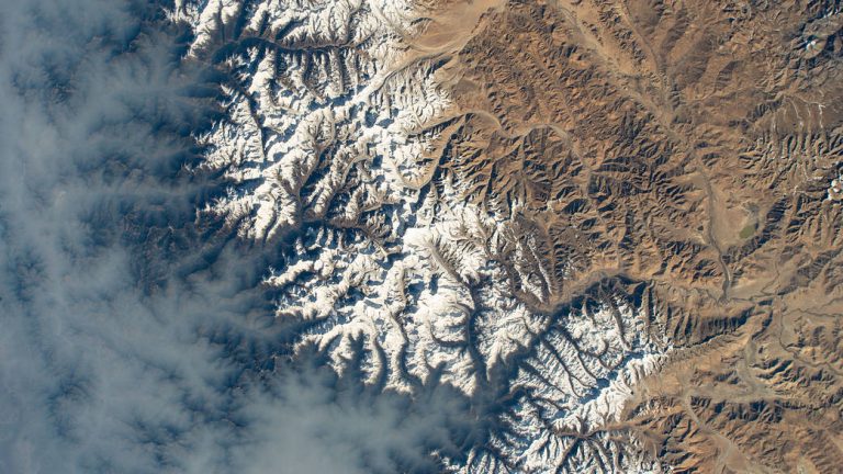
Clouds gather over Nepal near Mount Everest (center) in this April 13, 2023, photograph from the International Space Station. This image was taken as the station orbited 263 miles above the Indian subcontinent. In addition to photography, instruments on the space station like the Compact Ocean Wind Vector Radiometer and the Temporal Experiment for Storms and Tropical Systems allow us to monitor weather and collect important data. Image Credit: NASA 2023年4月13日,国际空间站拍摄的照片中,尼泊尔珠穆朗玛峰(中)附近的云层聚集在一起。这张照片是空间站在印度次大陆上空263英里的轨道上拍摄。 除了摄影之外,空间站上的仪器,如紧凑型海洋风矢量辐射计和风暴和热带系统时间实验,使我们能够监测天气并收集重要数据。 影像来源:NASA
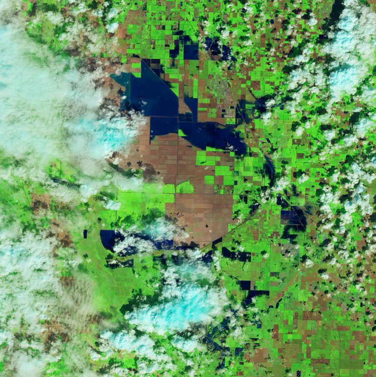
Floodwater (dark blue) stands out against the vegetation in agricultural fields around Tulare Lake near Corcoran, California, in this enhanced color image taken by Landsat 8 on March 29, 2023. Heavy rain and snow in the first three months of 2023 have once again brought water to Tulare’s lakebed, but also flooding several nearby towns. 2023 has been the wettest year in the region’s history. Tulare Lake, in California’s San Joaquin Valley, was once the largest freshwater lake west of the Mississippi River. By 1920, the rivers that fed the lake were dammed and diverted for uses such as irrigation. Since then, the lakebed has been covered with farms that grow a variety of crops. See what the region looked like in March 2022. Image…