观星指南(2022年10月)
十月份的天空会发生什么?夜晚有巨行星,火星改变方向,来自猎户座的流星。

十月份的天空会发生什么?夜晚有巨行星,火星改变方向,来自猎户座的流星。
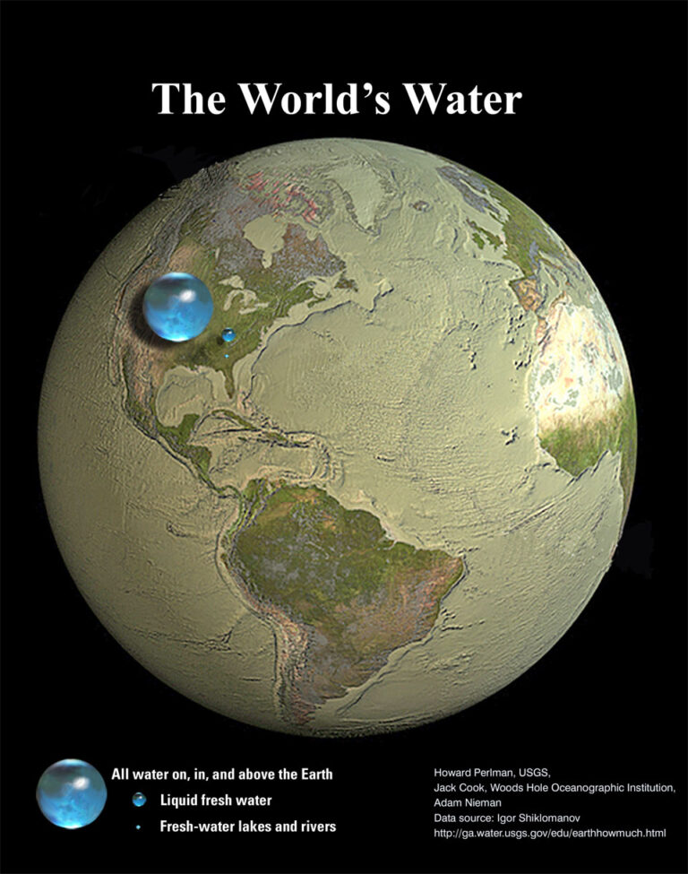
2022年9月26日 All the Water on Planet Earth Illustration Credit: Jack Cook, Adam Nieman, Woods Hole Oceanographic Institution; Data source: Igor Shiklomanov Explanation: How much of planet Earth is made of water? Very little, actually. Although oceans of water cover about 70 percent of Earth’s surface, these oceans are shallow compared to the Earth’s radius. The featured illustration shows what would happen if all of the water on or near the surface of the Earth were bunched up into a ball. The radius of this ball would be only about 700 kilometers, less than half the radius of the Earth’s Moon, but slightly larger than Saturn’s moon Rhea which, like many moons in our outer Solar System, is mostly water ice. The next smallest ball depicts…

European Space Agency astronaut Samatha Cristoforetti captured a photo of a portion of China’s Tanggula Mountains near Hala Lake as the International Space Station orbited 260 miles above the Earth on Sept. 5, 2022. Since the station began hosting human astronauts in November 2000, crew members have produced hundreds of thousands of images of the land, oceans, and atmosphere of Earth, and even of the Moon through Crew Earth Observations. Their photographs of Earth record how the planet changes over time due to human activity and natural events. This allows scientists to monitor disasters, direct response on the ground and study a number of phenomena, from the movement of glaciers to urban wildlife. Image credit: NASA 2022年9月5日,国际空间站在距地球260英里的高空绕轨道运行时,欧洲航天局宇航员萨马塔·克里斯托弗雷蒂拍摄到了中国哈拉湖附近唐古拉山脉的一部分。 自空间站于2000年11月开始接待人类宇航员以来,宇航员通过对地球的观测,拍摄了数十万张地球的陆地、海洋和大气层,甚至月球的图像。他们拍摄的地球照片记录了地球是如何随着人类活动和自然事件而随时间变化。这使科学家能够监测灾害,直接在地面作出反应,并研究从冰川运动到城市野生动物的许多现象。 影像来源:NASA

This nighttime photograph from the International Space Station (ISS) as it orbited 261 miles above Earth looks across the Mediterranean Sea from north Africa to southern Europe. The city lights of Algiers, Algeria to Tunis, Tunisia highlight Africa’s northern coast from the bottom center toward the upper right. From far left, the lights of city-state Monaco to Naples, Italy define the shores of southern Europe. The French island of Corsica and the Italian island of Sardinia are also pictured. The ISS circles the Earth every 90 minutes, traveling at about 17,500 miles (28,000 km) per hour. Find out where the ISS is now. Image credit: NASA 这张由国际空间站(ISS)在地球上空261英里的轨道上拍摄的夜间照片,从北非到南欧,横跨地中海。从阿尔及利亚的阿尔及尔到突尼斯的突尼斯城,城市的灯光从底部中心向右上角显示出了非洲的北部海岸。从最左边开始,城市国家摩纳哥到意大利那不勒斯的灯光定义了欧洲南部的海岸。法国科西嘉岛和意大利撒丁岛也在照片中。 国际空间站每90分钟绕地球一周,以每小时17,500英里(28,000公里)的速度运行。找出国际空间站现在的位置。 影像来源:NASA

九月份的天空会发生什么?火星在移动,木星的最佳观测时间,以及一个在秋分点寻找方位的巧妙方法。
2022年8月22日 Earth’s Recent Climate Spiral Video Credit: NASA’s Scientific Visualization Studio Explanation: Is our Earth warming? Compared to the past 250 million years, the Earth is currently enduring a relative cold spell, possibly about four degrees Celsius below average. Over the past 120 years, though, data indicate that the average global temperature of the Earth has increased by nearly one degree Celsius. The featured visualization video depicts Earth’s recent global warming in graphic terms. The depicted temperatures are taken from the Goddard Institute for Space Studies’ Surface Temperature Analysis. Already noticeable by many, Earth’s recent warming trend is causing sea levels to rise, precipitation patterns to change, and pole ice to melt. Few now disagree that recent global warming is occurring, and the Intergovernmental Panel…
2022年8月9日 Leaving Earth Video Credit: NASA/JHU Applied Physics Lab/Carnegie Inst. Washington Explanation: What it would look like to leave planet Earth? Such an event was recorded visually in great detail by the MESSENGER spacecraft as it swung back past the Earth in 2005 on its way in toward the planet Mercury. Earth can be seen rotating in this time-lapse video, as it recedes into the distance. The sunlit half of Earth is so bright that background stars are not visible. The robotic MESSENGER spacecraft is now in orbit around Mercury and has recently concluded the first complete map of the surface. On occasion, MESSENGER has continued to peer back at its home world. MESSENGER is one of the few things created on the Earth that…
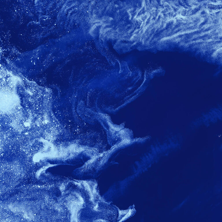
Like distant galaxies amid clouds of interstellar dust, chunks of sea ice drift through graceful swirls of grease ice in the frigid waters of Foxe Basin near Baffin Island in the Canadian Arctic. Sea ice often begins as grease ice, a soupy slick of tiny ice crystals on the ocean’s surface. As the temperature drops, grease ice thickens and coalesces into slabs of more solid ice. This image was acquired 20 years ago today by the Landsat 7 satellite. To learn more about the NASA/USGS Landsat Program, visit https://landsat.gsfc.nasa.gov. Image Credit: USGS/NASA/Landsat 7 在加拿大北极巴芬岛附近的福克斯盆地寒冷的海水中,大块的海冰像星际尘埃云中的遥远星系一样,漂浮在优雅的油脂状冰漩涡中。海冰通常以油脂状冰开始,油脂状冰是海洋表面的一种由微小冰晶组成的粘性滑面。随着温度下降,油脂状冰变厚并聚结成更坚固的冰块。 这幅图像是20年前的今天由陆地资源卫星7号卫星拍摄的。如欲了解有关NASA/USG陆地资源卫星计划的更多信息,请访问https://landsat.gsfc.nasa.gov. 影像来源:USGS/NASA/Landsat 7
这段循环视频显示了2022年1月15日洪加汤加洪加哈拜火山水下喷发产生的伞状云。GOES-17卫星拍摄了一系列图像,其中还显示了新月形冲击波和闪电。 影像来源:NASA Earth Observatory image by Joshua Stevens using GOES imagery courtesy of NOAA and NESDIS NASA的微波临边探测器探测到,大量的水蒸气涌入大气层,最终可能导致地球表面暂时变暖。 1月15日,亨加汤加-亨加-哈拜火山爆发,引发了一场席卷全球的海啸,并引发了环绕地球两周的音爆。南太平洋海底的火山喷发还向地球平流层喷射出巨大的水蒸气,足以填满58,000多个奥运会大小的游泳池。大量的水蒸气足以暂时影响地球的全球平均温度。 “我们从未见过这样的景象。”南加州NASA喷气推进实验室的大气科学家路易斯·米兰说。他领导了一项新的研究,研究汤加火山注入平流层的水蒸气量,平流层是地球表面上方约8至33英里(12至53公里)的大气层。 在这项发表在《地球物理研究快报》上的研究中,米兰和他的同事估计汤加火山爆发向地球平流层输送了约146太克(1太克相当于1万亿克)的水蒸气——相当于大气层中已经存在的水的10%。这几乎是科学家估计的1991年菲律宾皮纳图博火山喷发进入平流层的水汽量的四倍。 这张卫星图像显示,2015年4月,在2022年1月爆发的水下火山喷发摧毁了波利尼西亚岛的大部分之前,洪阿哈阿帕伊岛仍然完好无损。 影像来源:NASA Earth Observatory image by Jesse Allen, using Landsat data from the U.S. Geological Survey 米兰分析了来自NASA Aura卫星上的微波临边探测器(MLS)仪器的数据,该仪器测量大气气体,包括水蒸气和臭氧。汤加火山爆发后,MLS团队开始看到超出图表的水蒸气读数。“我们必须仔细检查喷流中的所有测量结果,以确保数据可信。”米兰说。 持久的印象 火山爆发很少向平流层输送大量的水。在NASA进行测量的18年中,只有另外两次喷发(2008年阿拉斯加的喀拉喀托火山和2015年智利的卡尔布科喷发)向如此高的海拔地区输送了相当数量的水蒸气。但与汤加事件相比,这些只是昙花一现,之前两次喷发的水蒸气都很快消散。另一方面,汤加火山注入的过量水蒸气可能会在平流层中停留数年。 这些额外的水蒸气可能会影响大气化学,促进某些化学反应,从而暂时加剧臭氧层的损耗。它还可能影响地表温度。像喀拉喀托火山和皮纳图博火山这样的大规模火山喷发通常通过喷射气体、灰尘和火山灰将阳光反射回太空来冷却地球表面。相比之下,汤加火山没有向平流层注入大量气溶胶,喷发产生的大量水蒸气可能会产生短暂的小增温效应,因为水蒸气可以吸收热量。当额外的水蒸气从平流层循环出去时,这种影响将消失,不足以显著加剧气候变化的影响。 2022年1月16日的图像显示了前一天发生的洪阿哈阿帕伊岛火山火山喷发的火山灰喷流。一名宇航员从国际空间站拍下了喷流的照片。 影像来源:NASA 注入平流层的水量之大可能是因为水下火山口(一个盆地状的凹陷,通常是在岩浆喷发或从火山下面的一个浅腔中流出后形成)正好位于海洋中的合适深度:大约490英尺(150米)以下。如果浅一点,就不会有足够多的海水被喷发的岩浆加热,来解释米兰和他的同事们看到的平流层水蒸气值。如果再深一点,海洋深处的巨大压力就可能抑制火山喷发。 MLS仪器非常适合检测这种水蒸气喷流,因为它可以观测到从地球大气层发出的自然微波信号。 测量这些信号,MLS能够“看穿”火山灰云这样的障碍物,这些障碍物可以遮挡其他测量平流层水汽的仪器。“MLS 是唯一一台覆盖密度足够大的仪器,能够捕捉到当时的水蒸气喷流,也是唯一一台不受火山灰影响的仪器。”米兰说。 MLS仪器由JPL设计和制造,由位于帕萨迪纳的加州理工学院为NASA管理。NASA戈达德航天飞行中心负责Aura任务。 参考来源: https://www.nasa.gov/feature/jpl/tonga-eruption-blasted-unprecedented-amount-of-water-into-stratosphere
八月份的天空会发生什么?拿起你的双筒望远镜来观测行星,展望英仙座,以及和天鹅座一起翱翔。