巴西利亚市上空的阿特拉斯彗星

巴西利亚市上空的阿特拉斯彗星

The buildings of a city are seen past a dark waterway. Over the city are some dark clouds and above that, blue sky. In the blue sky, partly obscured by some of the clouds, is a comet with a very long tail, running from the middle to the top of the frame. Please see the explanation for more detailed information.
透过一条漆黑的水道可以看到一座城市的建筑。城市上空有一些乌云,而更高处是蓝天。在蓝天中,一颗彗星穿过部分云层,其长长的彗尾从画面的中部延伸到顶部。有关更多详细信息,请参阅说明。

夜空的倒影

夜空的倒影

2021年9月13日 Night Sky Reflected Image Credit & Copyright: Egon Filter Explanation: What’s that in the mirror? In the featured image of the dark southern sky, the three brightest galaxies of the night are all relatively easy to identify. Starting from the left, these are the Small Magellanic Cloud (SMC), the Large Magellanic Cloud (LMC), and part of the central band of our Milky Way Galaxy. All three are also seen reflected in a shallow pool of water. But what is seen in the mirror being positioned by the playful astrophotographer? Dust clouds near the center of our Milky Way — and the planet Jupiter. The composite was carefully planned and composed from images captured from the same camera in the same location and during the…

古巴西的星座

古巴西的星座

2021年01月12日 A Historic Brazilian Constellation Image Credit & Copyright: Rodrigo Guerra Explanation: The night sky is filled with stories. Cultures throughout history have projected some of their most enduring legends onto the stars above. Generations of people see these stellar constellations, hear the associated stories, and pass them down. Featured here is the perhaps unfamiliar constellation of the Old Man, long recognized by the Tupi peoples native to regions of South America now known as Brazil. The Old Man, in more modern vernacular, may be composed of the Hyades star cluster as his head and the belt of Orion as part of one leg. Tupi folklore relates that the other leg was cut off by his unhappy wife, causing it to end at the orange…

远眺船底座星云

远眺船底座星云

2020 May 5 Carina in Perspective Image Credit & Copyright: Carlos Kiko Fairbairn Explanation: You need to be in the south, looking south, to see such a sky. And only then if you’re lucky. Just above the picturesque tree is the impressive Carina Nebula, one of the few nebulas in the sky that is visible to the unaided eye. The featured image had to be taken from a very dark location to capture the Carina Nebula with such perspective and so near the horizon. The Great Nebula in Carina, cataloged as NGC 3372, is home to the wildly variable star Eta Carinae that sometimes flares to become one of the brightest stars in the sky. Above Carina is IC 2944, the Running Chicken Nebula, a…

巴西上空的猎户座

巴西上空的猎户座

2019 September 30 Orion Rising over Brazil Image Credit & Copyright: Carlos Fairbairn Explanation: Have you seen Orion lately? The next few months will be the best for seeing this familiar constellation as it rises continually earlier in the night. However, Orion’s stars and nebulas won’t look quite as colorful to the eye as they do in this fantastic camera image. In the featured image, Orion was captured by camera showing its full colors last month over a Brazilian copal tree from Brazil’s Central-West Region. Here the cool red giant Betelgeuse takes on a strong orange hue as the brightest star on the far left. Otherwise, Orion’s hot blue stars are numerous, with supergiant Rigel balancing Betelgeuse at the upper right, Bellatrix at the upper…

2019年亚马孙大火比往年更活跃

2019年亚马孙大火比往年更活跃

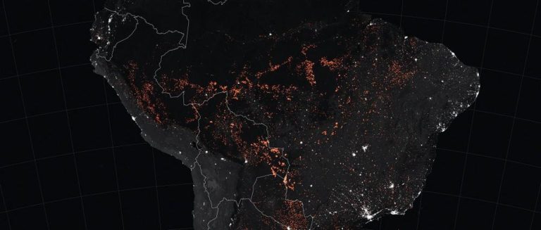
来源:NASA 2019年8月19日,NASA Terra卫星上的MODIS仪器捕获了一幅自然彩色图像,显示巴西帕拉州新普罗格雷索附近的火灾。该镇位于BR-163公路(一条南北向的高速公路)沿线,连接亚马孙南部的农民和亚马孙河上圣塔伦的远洋港口。高速公路周围聚集了牧场和农田,西边的蜿蜒道路连接着小型矿井,深入雨林。 随着亚马孙火灾季接近中点,科学家使用NASA卫星跟踪大火活动证实,2019年巴西亚马孙火灾的数量和强度都有所增加,这是自2010年以来该地区火灾最活跃的一年。 由于经济条件和气候的变化,亚马孙的火灾活动每年每月都有很大差异。NASA戈达德太空飞行中心生物圈科学实验室主任Douglas Morton解释说,今年8月,巴西中部亚马孙主道上的大火格外强烈并持续地燃烧十分引人注目。虽然干旱在过去加剧火灾方面起到了重要作用,但2019年旱季早期火灾探测的时间和地点,比起区域性干旱,与地面清理更为一致。 “卫星通常会第一个发现亚马孙偏远地区的火灾,”Morton说道。自2002年以来,NASA用于火灾探测的主要工具是Terra和Aqua卫星上的中分辨率成像光谱仪(MODIS)。 到目前为止,整个巴西亚马孙地区2019年的MODIS火灾活动探测高于2010年以来的任何一年。亚马孙州有望在2019年更新火灾活动纪录。 Morton指出,来自NASA和巴西国家环境保护协会(INPE)的2019年火灾活动统计数据达成一致。“INPE也利用NASA MODIS传感器的数据来监测巴西亚马孙的火灾活动,”Morton说,“因此,NASA和INPE对近期火灾活动的变化估计相同。在巴西亚马孙所包括的所有七个州,MODIS检测率都比去年同期高。” 全球火灾排放数据库(GFED)项目负责MODIS火灾探测分析,该项目包括来NASA戈达德、加州大学欧文分校、和阿姆斯特丹自由大学的研究员。多年来,GFED团队已经处理了17年的NASA卫星数据以更好地了解火灾对地球系统变化的作用。他们对亚马孙南部的分析包括巴西、秘鲁、和玻利维亚的部分地区,该地区通常在7月至10月间发生火灾。 [rml_read_more] 2012年1月1日至2019年8月21日 来源:NASA 2012年1月1日至2019年8月21日 来源:NASA 这些图显示了截至2019年8月22日,MODIS和索米国家极地轨道伙伴卫星(Suomi NPP)上的可见红外成像辐射计套件(VIIRS)累积检测到的火灾活动。数据证实,2019年是2012年(VIIRS开始记录)以来,巴西亚马孙七个州的最多火灾年度。此外,累积火灾辐射功率的记录表示2019年的火灾比往年更加激烈。 2012年1月1日至2019年8月21日 来源:NASA 2012年1月1日至2019年8月21日 来源:NASA 2019年8月15日至22日 来源:NASA 上图显示了Terra和Aqua MODIS在2019年8月15日至22日期间对巴西火灾活动的探测。火灾的位置(橙色显示)覆盖在VIIRS获得的夜间图像上。在这些数据中,城镇呈现白色,森林覆盖的区域呈黑色,热带稀树草原和林地(在巴西称为Cerrado)呈灰色。巴西帕拉州和亚马孙州的火灾探测集中在BR-163和BR-230高速公路沿线。 2019年8月8日至22日,巴西亚马孙地区上空与火灾相关的一氧化碳变化。这张动图由NASA的Aqua卫星上的大气红外线探测器(AIRS)绘制,显示了海拔大约5500米上空一氧化碳的变化 来源:NASA 自2003年以来,NASA的Aqua和Terra卫星上的MODIS传感器每天都在观察世界各地的热异常(通常是火灾)。火灾探测地图基于资源管理系统火灾信息(FIRMS)的数据,该系统由马里兰大学和NASA的应用科学计划开发。FIRMS为自然资源管理者和研究人员提供近实时的火灾信息。值得注意的是,地图上的每个点不一定直接对应地面上的一个火灾。火灾活动探测代表1平方公里区域的中心,该区域具有一个或多个热异常。有时一次连续火灾会被记录为排成一行的多个异常,代表火灾前沿。 参考: [1]https://earthobservatory.nasa.gov/images/145498/uptick-in-amazon-fire-activity-in-2019 [2]https://www.jpl.nasa.gov/news/news.php?feature=7486