日全食

日全食

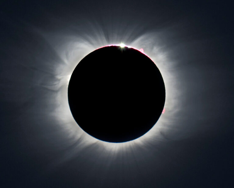
2021年12月09日 A Total Eclipse of the Sun Image Credit & Copyright: Theo Boris, Christian A. Lockwood, David Zimmerman (JM Pasachoff Antarctic Expedition) Compositing: Zev Hoover and Ronald Dantowitz (MARS Scientific) Explanation: Few were able to stand in the Moon’s shadow and watch the December 4 total eclipse of the Sun. Determined by celestial mechanics and not geographical boundaries, the narrow path of totality tracked across planet Earth’s relatively inaccessible southernmost continent. Still, some enthusiastic and well-insulated eclipse chasers were rewarded with the dazzling spectacle in Antarctica’s cold but clear skies. Taken just before the brief totality began, this image from a ground-based telescope inside the edge of the shadow path at Union Glacier catches a glimmer of sunlight near the top of the silhouetted lunar…

南极的日全食

南极的日全食

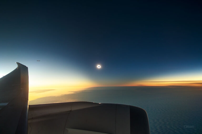
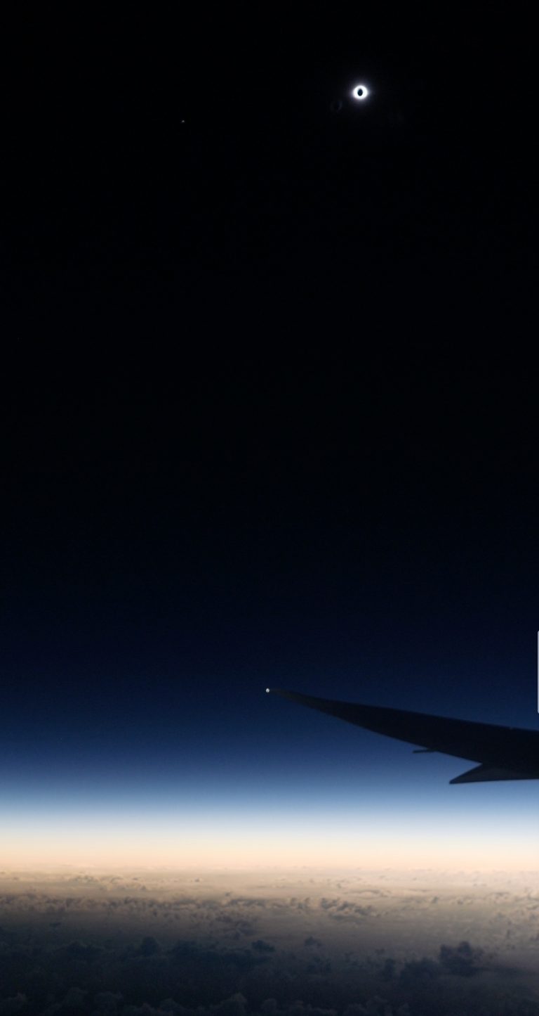
2021年12月05日 Total Solar Eclipse Below the Bottom of the World Image Credit & Copyright: Petr Horálek (ESO Photo Ambassador, Inst. of Physics in Opava) Explanation: Yesterday there was a total solar eclipse visible only at the end of the Earth. To capture the unusual phenomenon, airplanes took flight below the clouded seascape of Southern Ocean. The featured image shows one relatively spectacular capture where the bright spot is the outer corona of the Sun and the eclipsing Moon is seen as the dark spot in the center. A wing and engine of the airplane are visible across the left and bottom of the image, while another airplane observing the eclipse is visible on the far left. The dark area of the sky surrounding the eclipsed…

2020年日全食

2020年日全食

2021年01月07日 Total Solar Eclipse 2020 Image Credit & Copyright: Miloslav Druckmuller, Andreas Moller, (Brno University of Technology), Explanation: Along a narrow path crossing southern South America through Chile and Argentina, the final New Moon of 2020 moved in front of the Sun on December 14 in the year’s only total solar eclipse. Within about 2 days of perigee, the closest point in its elliptical orbit, the New Moon’s surface is faintly lit by earthshine in this dramatic composite view. The image is a processed composite of 55 calibrated exposures ranging from 1/640 to 3 seconds. Covering a large range in brightness during totality, it reveals the dim lunar surface and faint background stars, along with planet-sized prominences at the Sun’s edge, an enormous coronal mass…

日全食期间的地球

日全食期间的地球

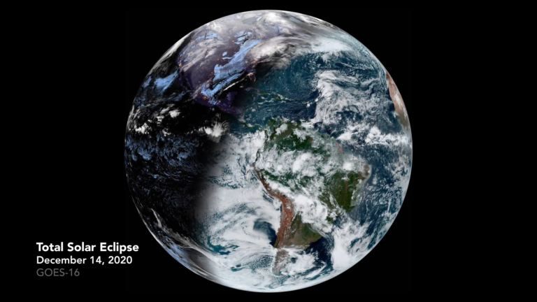
2020年12月29日 Earth During a Total Solar Eclipse Video Credit: GOES-16, ABI, NOAA, NASA Explanation: What does the Earth look like during a total solar eclipse? It appears dark in the region where people see the eclipse, because that’s where the shadow of the Moon falls. The shadow spot rapidly shoots across the Earth at nearly 2,000 kilometers per hour, darkening locations in its path — typically for only a few minutes — before moving on. The featured video shows the Earth during the total solar eclipse earlier this month. The time-lapse sequence, taken from a geostationary satellite, starts with the Earth below showing night but the sun soon rises at the lower right. Clouds shift as day breaks over the blue planet. Suddenly the circular…

日全食与倒影

日全食与倒影

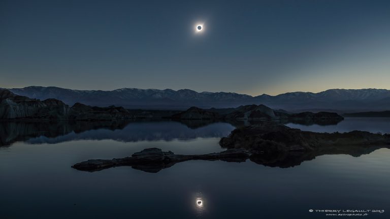
2019 August 5 A Total Solar Eclipse Reflected Image Credit & Copyright: Thierry Legault Explanation: If you saw a total solar eclipse, would you do a double-take? One astrophotographer did just that — but it took a lake and a bit of planning. Realizing that the eclipse would be low on the horizon, he looked for a suitable place along the thin swath of South America that would see, for a few minutes, the Moon completely block the Sun, both directly and in reflection. The day before totality, he visited a lake called La Cuesta Del Viento (The Slope of the Wind) and, despite its name, found so little wind that the lake looked like a mirror. Perfect. Returning the day of the eclipse, though,…

鸟类和日全食

鸟类和日全食

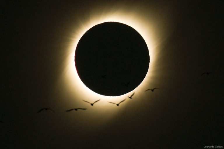
2019 July 9 Birds During a Total Solar Eclipse Image Credit & Copyright: Leonardo Caldas Explanation: What do birds do during a total solar eclipse? Darkness descends more quickly in a total eclipse than during sunset, but returns just as quickly — and perhaps unexpectedly to the avians — just a few minutes later. Stories about the unusual behavior of birds during eclipses have been told for centuries, but bird reactions were recorded and studied systematically by citizen scientists participating in an eBird project during the total solar eclipse that crossed the USA in 2017 August. Although some unusual behaviors were observed, many observers noted birds acting like it was dusk and either landing or flying low to the ground. Radar confirmed a significant decrease…

日全食使南太平洋变暗

日全食使南太平洋变暗

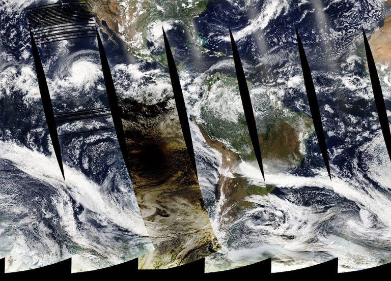
2019年7月2日,当地时间下午4点38分,智利海滨城市拉塞丽娜的天文爱好者抬头看到天空中有一个黑色的圆圈。天空的其余部分笼罩在橙色的暮色中,地面附近的温度暂时下降了几度。这并不是世界末日的征兆,而是一次日全食——当月亮直接经过地球和太阳之间,完全遮住了日冕。 当日食追踪者向上看的时候,NASA的卫星向下看地球表面。Aqua卫星上的中分辨率成像光谱仪(MODIS)传感器捕捉到了这张月球阴影向东穿越南太平洋的照片。日蚀投下的阴影由完全变暗的阴影和部分变暗的半影组成。 Aqua卫星有一个极地轨道,MODIS传感器收集的图像宽约2330公里(1450英里)。这幅图像是由三次不同时间采集的数据拼接而成的。图像的左三分之一是在宇宙时间21:40,在日全食之后拍摄的。中间的狭长地带是在世界时间20:00左右拍摄的,当时日全食正在南太平洋上空。右边的第三张图显示的是智利在世界时间18:13到18:32之间(当地时间下午2:13到2:32),在日全食之前拍摄的。图像中的黑色间隙是赤道(地球最宽点)附近的地方,MODIS的拍摄区域在某一天内不会相交。 当月球的直径比恒星小400倍时,它是如何遮住太阳的呢?这是因为月球的轨道。月球绕地球运行的轨道略呈椭圆形,就像一个以地球为中心的扁圆。因此,月球与地球的距离并不总是相同的。当月球离地球最近时,它会比离地球较远时略大一些。在日全食期间,月球离地球的距离是太阳离地球距离的400倍,这抵消了月球直径相差400倍的影响。 从一个特定的位置看到日全食是很罕见的。平均来说,地球上相同的地点大约每375年就会发生几分钟的日食,尽管地球上的某个地方大约一年半就会发生一次日全食。下一次日全食将于2020年12月14日发生在南太平洋、智利、阿根廷和南大西洋上空。下一次在北美出现的日全食将发生在2024年4月8日。 On July 2, 2019, skywatchers in the beach city of La Serena, Chile, looked up at 4:38 p.m. local time to see a black circle in the sky. The rest of the sky was shaded in orange twilight, and the temperature near the ground momentarily dropped by a few degrees. It wasn’t a sign of the apocalypse, but a total solar eclipse—when the Moon passes directly between the Earth and the Sun and completely obscures the disk. As eclipse chasers were looking up, NASA satellites were looking down at Earth’s surface. The Moderate Resolution Imaging Spectroradiometer (MODIS) sensor on the Aqua satellite captured this view of the Moon’s shadow as it traveled eastward across the South Pacific. The shadow cast…

持续8分30秒的日全食

持续8分30秒的日全食

2019 July 6 持续8分30秒的日全食 影像提供与版权: Bob Minor 说明: 在7月2日的日食期间,全食阶段最长约可持续4分30秒。能见到这个最长全食的地点,在地球表面·复活岛北方大约1,100公里的南太平洋面上。不过,如果位在和月食交错,离地表11,277公尺的包机上,月亮完全遮住太阳的期间可拉长到8分30秒。当时位在食甚拦截点的这部飞机,在顺风相助之下,大约以900公里的时速沿着全食带追月。摄影者从云层上方的飞机向阳靠窗坐位,拍下这幅的壮观大视野影像,并记录了悬在机翼上方的全食日和荧荧日冕。 8 Minute and 30 Second Eclipse Image Credit & Copyright: Bob Minor Explanation: The total phase of the July 2nd solar eclipse lasted about 4 minutes and 30 seconds at the point of maximum eclipse. On the surface of planet Earth, that was about 600 nautical miles north of Easter Island in the Southern Pacific Ocean. But from 37,000 feet above, on a charter flight intercepting the Moon’s shadow, the Moon could be seen to completely block the Sun for about 8 minutes and 30 seconds. With a tailwind at the mid-eclipse intercept point, the plane was traveling around 488 nautical miles per hour chasing along the Moon’s shadow track. From above the clouds this wide-field…

拉西亚天文台的日食系列影像

拉西亚天文台的日食系列影像

2019 July 5 拉西亚天文台的日食系列影像 影像提供与版权: Petr Horálek 说明: 前往峰顶拉西亚天文台的引道,恰好也在7月2日全食的全食带上,所以看似指向全食日。这个寻常的日食序列,中心点在月球的暗影,恰好盖住数部地球数部最大型望远镜之瞬间。事实上,拉西亚天文台在全食带中心线偏北一点的位置。因此,这片异常澄澈的天空,右侧(北方)的区域较为明亮。这个梦境般的景观,西眺落日与全食带月影飞掠而来的方向。 La Silla Eclipse Sequence Image Credit & Copyright: Petr Horálek Explanation: The road to the high mountaintop La Silla Observatory in the Chilean Atacama Desert also led in to the path of July 2nd’s total solar eclipse. Recorded at regular intervals before and after the total eclipse phase, the frames in this composite sequence include the moment the Moon’s dark shadow fell across some of planet Earth’s advanced large telescopes. The dreamlike view looks west toward the setting Sun and the approaching Moon shadow. In fact La Silla was a little north of the shadow track’s center line, so the region’s stunning, clear skies are slightly brighter to the north (right) in the scene.

站在月球的影子里

站在月球的影子里

2019 July 4 站在月球的影子里 影像提供与版权: Yuri Beletsky (Carnegie Las Campanas Observatory, TWAN) 说明: 在2019年7月2日的南美洲日全食期间,地球的住民可伫足在月球黝黑的本影里。月球本影和地面的初始接触点,在纽西兰东方的太平洋面,然后沿狭窄的路径向东飞掠,当太阳低垂在西方地平线上空时,本影恰好切过智利的太平洋岸。在上面这幅影像里,在食甚之前的瞬间,最后一丝漏过的阳光,曳出了前景的长长影子。而转瞬将进入全食阶段的太阳,在幽暗明澈的天空中,形似美丽的钻石环。太阳边缘的绕射芒,则是由相机镜头的光圈所造成的。 In the Shadow of the Moon Image Credit & Copyright: Yuri Beletsky (Carnegie Las Campanas Observatory, TWAN) Explanation: On July 2 denizens of planet Earth could stand in the Moon’s dark umbral shadow during South America’s 2019 total solar eclipse. It first touched down in the Southern Pacific Ocean, east of New Zealand. Racing toward the east along a narrow track, the shadow of the Moon made landfall along the Chilean coast with the Sun low on the western horizon. Captured in the foreground here are long shadows still cast by direct sunlight though, in the final moments before totality began. While diffraction spikes are from the camera lens aperture, the…