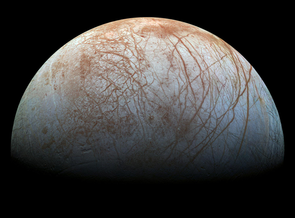
塔楚拉山脉的夜空

塔楚拉山脉的夜空

A starry sky is shown with the busy central band of our Milky Way Galaxy showing diagonally from the upper left. Mountains are on the horizon, with trees and a stream running up from the foreground. Please see the explanation for more detailed information.
图中显示的是一片繁星满天的天空,银河系的中央盘面从左上方斜向外显示。地平线上有群山,前景中有树木和一条小溪。有关更多详细信息,请参阅说明。

绿湖的蓝绿色水域

绿湖的蓝绿色水域

Woody Hoburg took this photo of Laguna Verde’s inviting waters as the International Space Station orbited 264 miles (425 km) over South America on July 7, 2023. Laguna Verde, which has an altitude of over 14,000 feet (4,300 meters), is located in the Andes mountains of Chile. Even taller landmarks surround the high-altitude lake, including Ojos del Salado—the tallest peak in Chile and the highest volcano on Earth. See more photos of Earth taken by astronauts on the space station. Image Credit: NASA/Woody Hoburg 2023年7月7日,国际空间站在南美洲上空绕轨道飞行264英里(425公里)时,伍迪·霍伯格拍摄了这张绿湖迷人水域的照片。绿湖位于智利的安第斯山脉,海拔超过14,000英尺(4,300米)。高海拔湖泊周围甚至还有更高的地标,包括智利最高峰和地球上最高的火山——奥霍斯·德尔·萨拉多火山。 查看更多由宇航员在空间站拍摄的地球照片。 图片来源: NASA/Woody Hoburg

发光的北海

发光的北海

As sunlight and warmth increase in the spring and summer, the North Sea starts to gain swirls and tendrils of color. Phytoplankton—tiny, plant-like organisms that often float near the ocean surface—become abundant during this time, giving the shallow water the distinctive look seen in this June 14, 2023, image from Landsat 9. Phytoplankton turn sunlight and carbon dioxide into sugars and oxygen, and in turn, they become food for the grazing zooplankton, shellfish, and finfish of the sea. They also play an important but not fully understood role in the global carbon cycle, taking carbon dioxide out of the atmosphere and sinking it to the bottom of the ocean. NASA’s future Plankton, Aerosol, Cloud, ocean Ecosystem (PACE) satellite mission will allow researchers to infer more…

木卫二

木卫二

2023年5月20日 Galileo’s Europa Image Credit: NASA, JPL-Caltech, SETI Institute, Cynthia Phillips, Marty Valenti Explanation: Looping through the Jovian system in the late 1990s, the Galileo spacecraft recorded stunning views of Europa and uncovered evidence that the moon’s icy surface likely hides a deep, global ocean. Galileo’s Europa image data has been remastered here, with improved calibrations to produce a color image approximating what the human eye might see. Europa’s long curving fractures hint at the subsurface liquid water. The tidal flexing the large moon experiences in its elliptical orbit around Jupiter supplies the energy to keep the ocean liquid. But more tantalizing is the possibility that even in the absence of sunlight that process could also supply the energy to support life, making Europa one…

暴雨和大雪使图莱里湖恢复生机

暴雨和大雪使图莱里湖恢复生机

Floodwater (dark blue) stands out against the vegetation in agricultural fields around Tulare Lake near Corcoran, California, in this enhanced color image taken by Landsat 8 on March 29, 2023. Heavy rain and snow in the first three months of 2023 have once again brought water to Tulare’s lakebed, but also flooding several nearby towns. 2023 has been the wettest year in the region’s history. Tulare Lake, in California’s San Joaquin Valley, was once the largest freshwater lake west of the Mississippi River. By 1920, the rivers that fed the lake were dammed and diverted for uses such as irrigation. Since then, the lakebed has been covered with farms that grow a variety of crops. See what the region looked like in March 2022. Image…

巴塔哥尼亚浮游生物漩涡

巴塔哥尼亚浮游生物漩涡

Phytoplankton create rich blooms of color in the Atlantic Ocean near South America in this enhanced color image from Dec. 2, 2014. The Patagonian Shelf Break is a biologically rich patch of ocean where airborne dust from the land, iron-rich currents from the south, and upwelling currents from the depths provide a bounty of nutrients for phytoplankton. The bands of color seen here not only reveal the location of plankton, but also the dynamic eddies and currents that carry them. Image Credit: NASA/Norman Kuring; NOAA; DOD 2014年12月2日,在这张增强的彩色图像中,浮游植物在南美洲附近的大西洋上开出了丰富的花朵。巴塔哥尼亚大陆架断裂是一片生物丰富的海洋,来自陆地的空气尘埃、来自南方的富铁洋流和来自深处的上升流为浮游植物提供了丰富的营养。这里看到的彩色带不仅显示了浮游生物的位置,还揭示了携带浮游生物的动态漩涡和洋流。 影像来源:NASA/Norman Kuring; NOAA; DOD

路易斯安那州的稻田

路易斯安那州的稻田

This Feb 3, 2023, enhanced-color image from Landsat 9 highlights a green and blue patchwork pattern in flooded rice fields in southwestern Louisiana. Raised levees used for water management form the grid pattern between the fields, which appear dark blue. As it flowed through several southern states over tens of thousands of years, the Mississippi River left a valuable layer of fertile soil in its wake. This low-lying floodplain and the flat coastal prairies of Louisiana and Texas are now home to most of the rice farms in the United States. In 2021, Arkansas, Louisiana, Mississippi, and Texas—collectively known as the Rice Belt—produced about 73 percent of all rice in the United States. Image Credit: NASA 这张2023年2月3日的增强彩色图像来自陆地卫星9号,突出显示了路易斯安那州西南部被洪水淹没的稻田中绿蓝相间的图案。用于水管理的加高的堤坝形成了田地之间的网格图案,呈现深蓝色。 数万年来,密西西比河流经美国南部几个州,留下了一层宝贵的沃土。这片低洼的洪泛平原以及路易斯安那州和德克萨斯州平坦的沿海大草原现在是美国大部分水稻农场的所在地。2021年,阿肯色州、路易斯安那州、密西西比州和德克萨斯州(统称为水稻带)的水稻产量约占美国总产量的73%。 影像来源:NASA