雪崩、冰爆和沙丘: NASA正在追踪火星上的新年
在地球上,新年往往伴随着冬日的奇幻美景,而火星北半球则经历着一种活跃甚至是“爆炸式”的春季解冻。当我们在地球迎接即将到来的跨年夜时,火星科学家已经抢先了一步:火星在2024年11月12日完成了绕太阳的一次公转。为此,一些研究人员为这个“火星新年”举杯庆祝。

在地球上,新年往往伴随着冬日的奇幻美景,而火星北半球则经历着一种活跃甚至是“爆炸式”的春季解冻。当我们在地球迎接即将到来的跨年夜时,火星科学家已经抢先了一步:火星在2024年11月12日完成了绕太阳的一次公转。为此,一些研究人员为这个“火星新年”举杯庆祝。

This image taken by the Mars Reconnaissance Orbiter spacecraft’s HIRISE instrument on Oct. 23, 2022, of the northern plains of Arabia Terra shows craters that contain curious deposits with mysterious shapes and distribution. For instance, the deposits are located on the south sides of the craters, but not usually in the north, and are found only in craters larger than 600 meters in diameter. Scientists suspect that these features formed by sublimation of ice-rich material. Learn more about these crater deposits. Image Credit: NASA/JPL-Caltech/University of Arizona 2022年10月23日,这张由火星勘测轨道飞行器HIRISE仪器拍摄的阿拉伯半岛北部平原的照片显示,陨石坑中含有神秘形状和分布的奇怪沉积物。例如,这些沉积物通常位于陨石坑的南侧,而不在北侧,而且只在直径超过600米的陨石坑中发现。科学家怀疑这些特征是由富含冰的物质升华形成。 了解更多关于这些陨石坑沉积物的信息。 图片来源:NASA/JPL-Caltech/University of Arizona

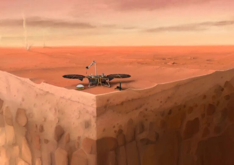
在这张NASA洞察号着陆器位于火星表面的示意图中,可以看到下方的火星地下结构层次,背景中则可以看到可怕的沙尘。 图片来源:巴黎地球物理研究所/尼古拉斯·萨特(Nicolas Sarter) 热探针始终无法获得挖掘所需的摩擦力,而该任务也已获得进一步指示,可以继续进行其他的科学工作了。 由德国航空航天中心(German Aerospace Center,DLR)开发和制造,美国航空航天局(NASA)洞察号(InSight)着陆器所部署在火星上的热探针,已经结束了它的相关任务。自2019年2月28日以来,这一名为“鼹鼠”(mole)的热探测器就一直在尝试深入火星表面之下,希望能测得火星的内部温度,为我们带来火星内部热源的详细信息,解释火星演化和地质改变的原因。但是火星土壤出乎意料的结块趋势,让长钉状的“鼹鼠”失去了将自己锤击到足够深度所需的摩擦力。 在“鼹鼠”的顶端钻入到表面下方约2或3厘米后,研究团队最后一次尝试了用洞察号机械臂上的勺子将土壤刮到探针之上,并夯实以增加摩擦。在2021年1月9日星期六,研究团队又追加了500次锤击,仍然毫无进展,只好宣布停止这一努力。 作为热流和物理特性探测仪(Heat Flow and Physical Properties Package,HP3)的一部分,“鼹鼠”是一种长约16英寸(40厘米)的自动钻地探测针,通过带有内置温度传感器的绳索与洞察号着陆器相连,一旦“鼹鼠”向下钻到10英尺(约3米)深的地方,这些传感器就会测量从火星内部的热流温度。 “我们已经作出了所有我们能作出的努力,但火星和我们英雄的‘鼹鼠’仍然不相兼容。”热流和物理特性探测仪的首席研究员、来自德国航空航天中心的蒂尔曼·斯波恩(Tilman Spohn)说道,“幸运的是,我们已经从中学到了很多东西,这将有益于将来尝试深入行星地表之下的任务。” 洞察的“鼹鼠”停止了努力:“鼹鼠”是一个热探测器,它搭乘NASA的洞察号火星着陆器到达火星,图中是它锤击努力之后的样子,时间为2021年1月9日,也就是洞察号火星任务的第754个火星日。自2019年2月28日起任务团队就开始尝试钻入探针,至此,团队宣布终止这一努力。 图片来源:NASA /喷气推进实验室-加州理工 除了NASA的凤凰号(Phoenix)火星着陆器刮取过火星表面的上层土壤,洞察号之前再没有任何任务曾试图钻入火星表面之下。这么做很重要,原因包括:未来的宇航员可能需要挖掘土壤以获取水冰,而科学家则希望研究地下物质来寻找支持微生物生命存在的可能线索。 “我们为我们的团队感到骄傲,他们为了让洞察号的‘鼹鼠’深入到火星地表之下作出了非常多的努力。他们能在数百万英里之外进行故障排除,这真是太了不起了,”NASA华盛顿总部的科学副主任托马斯·齐布亨(Thomas Zurbuchen)说道,“这就是我们在NASA冒险探索的原因:我们必须突破技术极限,去了解哪些方法是有效的、哪些方法是无效。从这个意义上讲,我们已经取得了成功:我们已经学到了很多东西,这些信息将使未来去往火星及其他地方的飞行任务受益,并且,我们感谢德国航空航天中心的合作伙伴提供了这一仪器,也感谢与他们的合作。” 来之不易的智慧 洞察号周围火星表面土壤出乎意料的特性,将在未来几年内仍然是科学家倍感困惑的谜团。“鼹鼠”是基于之前的火星飞行任务所见的土壤而设计的,结果发现,这些土壤与“鼹鼠”真实遇到的土壤结构有很大的不同。两年来,研究团队一直致力于用“鼹鼠”这一独特而创新的仪器去适应新的情况。 “‘鼹鼠’这一装置没有任何先迹可循。我们所尝试去做的,即用如此小型的设备进行如此深的挖掘,是史无前例的,”南加州NASA喷气推进实验室(Jet Propulsion Laboratory,JPL)的科学家兼工程师特洛伊·哈德森(Troy Hudson)说道,“曾有机会一直走到底,就是最大的收获。”一直以来,哈德森都在努力让“鼹鼠”更深地钻入火星地壳之中。 除了了解该位置的土壤信息外,工程师们还获得了操作机器臂的宝贵经验。实际上在任务一开始,他们就以他们从未设想过的方式操作使用着机械臂和挖铲,包括将土壤压实在“鼹鼠”上。对一系列动作进行规划,然后将相关指令正确地发送给洞察号,这些已足以推动任务团队的成长。 他们这来之不易的智慧将让他们在未来的任务中受益匪浅,该任务的目的是利用机械臂埋下在洞察号着陆器和地震仪之间传输数据和电力的拴绳。洞察号地震仪已经记录了480多次地震,埋下拴绳将有助于减少温度变化,而温度变化会在地震数据中产生破裂声和爆裂声。 洞察号全称为“运用地震调查、测地学与热传导对火星内部进行探测”(Interior Exploration using Seismic Investigations, Geodesy and Heat Transport),将为我们提供更多的科学知识。最近,NASA将洞察号火星探测任务延长了两年,到2022年12月。除了搜寻火星地震之外,这架着陆器还进行着一项无线电实验,实验的目的是收集相关数据,揭示火星拥有的是液态核还是固态核。洞察号的天气传感器能够提供在火星上所收集的最为详细的一批气象数据,等到2月18日NASA新的毅力号(Perseverance)火星车着陆火星表面,再加上好奇号(Curiosity)火星车,三辆火星车上的气象仪器将在另一颗星球上创建起第一个气象网络。 洞察号任务的更多相关信息 JPL为NASA的科学任务理事会(Science Mission Directorate)主导和管理洞察号火星探测任务。洞察号任务是NASA“发现计划”(Discovery Program)的一部分,由NASA位于阿拉巴马州亨茨维尔的马歇尔太空飞行中心(Marshall Space Flight Center,MSFC)管理。洞察号探测器(包括巡航级和着陆器)由位于丹佛的洛克希德·马丁太空空间系统公司(Lockheed Martin Space Systems Company,LMT)制造,LMT同时还支持了探测器的飞行任务。 包括法国国家空间中心(Centre National d’Études Spatiales,CNES)和德国航空航天中心(DLR)在内的许多欧洲合作伙伴正在为洞察号火星探测任务作出贡献。CNES向NASA提供了内部结构地震实验仪(SEIS),主要研究者来自巴黎地球物理研究所(Institut de Physique du Globe de Paris,IPGP)。为SEIS作出了重大贡献的机构包括法国IPGP、德国马克斯普朗克太阳系研究所(Max Planck Institute for Solar System Research,MPS)、瑞士联邦理工学院(Swiss Federal Institute of Technology,即苏黎世联邦理工学院ETH Zurich)、伦敦帝国理工学院(Imperial College London)、英国牛津大学(Oxford University)以及美国NASA喷气推进实验室(JPL)。DLR提供了热流和物理特性探测仪(HP3),波兰科学院(Polish Academy of Sciences)的空间研究中心(Space Research Center,CBK)和波兰的Astronika公司则对此作出了重要的贡献。温度和风力传感器由西班牙天体生物学中心(Centro de Astrobiología,CAB)提供。 参考来源: https://mars.nasa.gov/news/8836/nasa-insights-mole-ends-its-journey-on-mars/

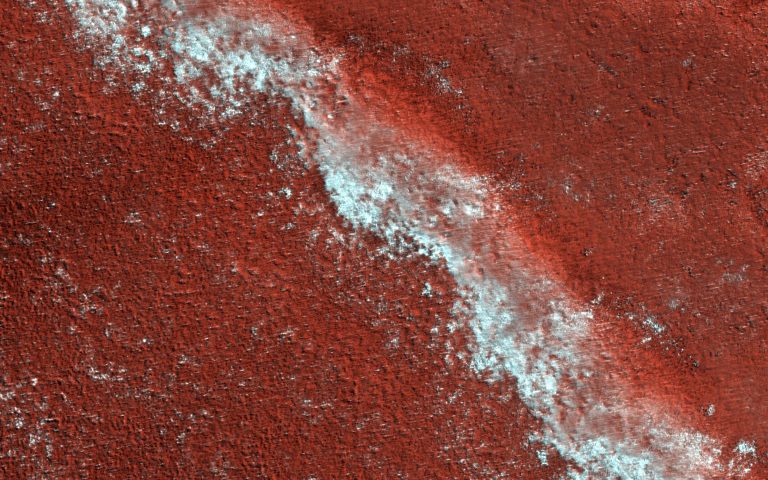
The Martian ice cap is like a cake with every layer telling a story. In this case, the story is one of climate change on Mars. This image of an exposed section of the north polar layered deposits (NPLD) looks much like a delicious slice of layered tiramisu. The NPLD is made up of water-ice and dust particles stacked one on top of the other. However, instead of icing, layers are topped with seasonal carbon dioxide frost, as seen here as lingering frost adhering to one of the layers. The high-resolution and color capabilities of the Mars Reconnaissance Orbiter’s HiRISE camera provides details on the variations in the layers. Scientists are also using radar data, which show us that they have continuity in the subsurface….

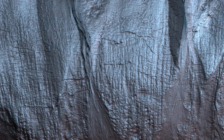
Gullies on Mars form during the winter, fluidized by carbon dioxide frost, and scientists monitor sites on the planet for activity throughout the year. In this mid-winter scene, a Martian gully is almost completely frosted over the pole-facing slope within the shadow. The map is projected here at a scale of 50 centimeters (19.7 inches) per pixel. (The original image scale is 50.5 centimeters [19.9 inches] per pixel [with 2 x 2 binning]; objects on the order of 152 centimeters [59.8 inches] across are resolved.) North is up. NASA’s Mars Reconnaissance Orbiter, launched August 12, 2005, continuously monitors the Red Planet from orbit and continues in its mission to search for evidence that water persisted on the surface of Mars for a long period of…

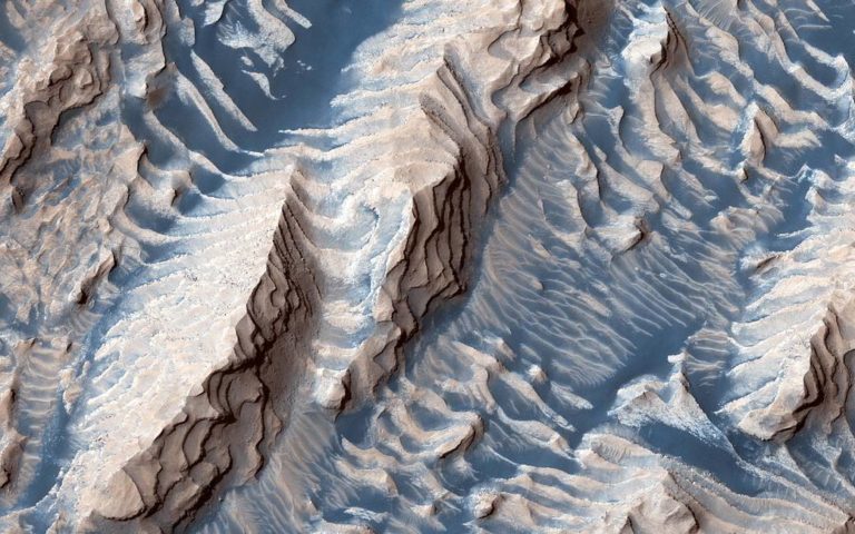
This image taken by the Mars Reconnaissance Orbiter spacecraft shows sedimentary rock and sand within Danielson Crater, an impact crater about 42 miles or 67 kilometers in diameter, located in the southwest Arabia Terra region of Mars. The rock was formed millions or billions of years ago when loose sediments settled into the crater, one layer at a time, and were later cemented in place. Cyclical variations in the sediment properties made some layers more resistant to erosion than others. After eons, these tougher layers protrude outward like stair steps. Across these steps, the winds have scattered sand (typically appearing darker and less red, i.e. “bluer” in contrast-enhanced color), giving rise to the zebra stripe-like patterns visible here. This image completes a stereo pair over…