西北地区的野火

西北地区的野火

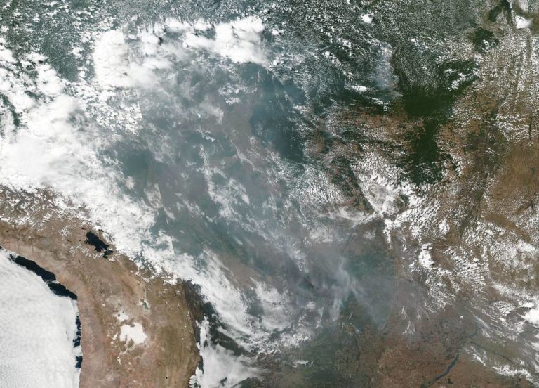
On August 8, 2023, the Moderate Resolution Imaging Spectroradiometer on NASA’s Aqua satellite captured this image of dense plumes of smoke streaming from dozens of large fires in the Northwest Territories. Several of these fires raged around Yellowknife, the province’s capital and largest city, where firefighters are conducting controlled burns around the city’s perimeter as a cautionary measure. These fires follow major outbreaks of fire in Alberta, British Columbia, Nova Scotia, and Quebec, in May, June, and July. Image Credit: NASA/Michala Garrison 2023年8月8日,NASA水卫星上的中分辨率成像光谱仪捕捉到了这张西北地区几十场大火产生的浓烟的图像。其中几起大火在该省首府和最大城市耶洛奈夫附近肆虐,消防队员正在城市周边进行可控的焚烧,以此作为警戒措施。这些火灾发生在五月、六月和七月阿尔伯塔省、不列颠哥伦比亚省、新斯科舍省和魁北克省的大火灾之后。 影像来源:NASA/Michala Garrison

巴西热带雨林的野火产生了跨越国家的烟雾

巴西热带雨林的野火产生了跨越国家的烟雾

This natural-color image of smoke and fires in several states within Brazil including Amazonas, Mato Grosso, and Rondônia was collected by NOAA/NASA’s Suomi NPP using the VIIRS (Visible Infrared Imaging Radiometer Suite) instrument on August 20, 2019. It is not unusual to see fires in Brazil at this time of year due to high temperatures and low humidity. Time will tell if this year is a record breaking or just within normal limits. NASA’s Earth Observing System Data and Information System (EOSDIS) Worldview application provides the capability to interactively browse over 700 global, full-resolution satellite imagery layers and then download the underlying data. Many of the available imagery layers are updated within three hours of observation, essentially showing the entire Earth as it looks “right…