太平洋上的日出

太平洋上的日出

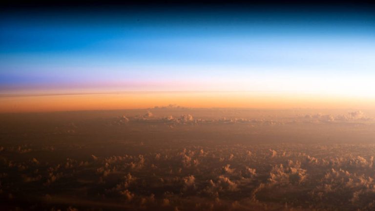
An orbital sunrise reveals cloud tops above the Pacific Ocean northeast of New Zealand as the International Space Station orbited 260 miles above on Feb. 10, 2023. Astronauts aboard the space station see 16 sunrises and sunsets per day due to their high orbital velocity—17,500 miles per hour. In the more than 20 years that people have been living aboard, the station has circumnavigated Earth tens of thousands of times. Image Credit: NASA 2023年2月10日,国际空间站在新西兰东北部的太平洋上空260英里轨道上运行,轨道上的日出显示出太平洋上空的云顶。由于轨道速度高(每小时17,500英里),空间站上的宇航员每天能看到16次日出和日落。在人们居住在空间站的20多年里,空间站已经环绕地球数万次。 影像来源:NASA

人为的夜空亮度

人为的夜空亮度

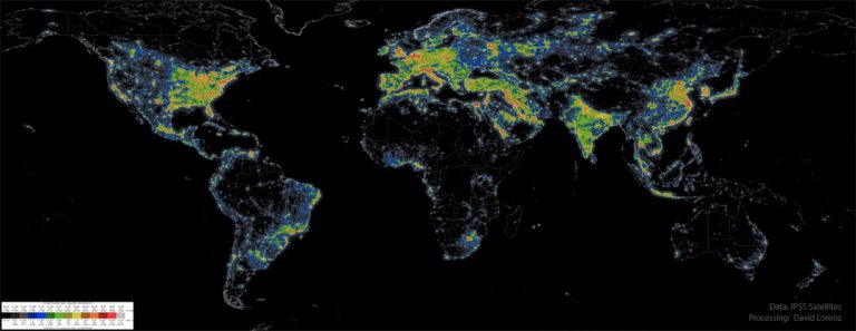
2023年3月8日 Artificial Night Sky Brightness Image Credit: Data: JPSS Satellites; Processing: David J. Lorenz Explanation: Where have all the dim stars gone? From many places on the Earth including major cities, the night sky has been reduced from a fascinating display of thousands of stars to a diffuse glow through which only a few stars are visible. The featured map indicates the relative amount of light pollution that occurs across the Earth. The cause of the pollution is artificial light reflecting off molecules and aerosols in the atmosphere. Parts of the Eastern United States and Western Europe colored red, for example, have an artificial night sky glow over ten times that of the natural sky. In any area marked orange or red, the central band…

从空间站拍摄到的飓风弗莱迪

从空间站拍摄到的飓风弗莱迪

Cyclone Freddy is pictured northeast of the island nation of Mauritius from the International Space Station as it orbited 267 miles above the Indian Ocean on Feb. 20, 2023. On the space station are two NASA-built weather instruments, the Compact Ocean Wind Vector Radiometer (COWVR) and the Temporal Experiment for Storms and Tropical Systems (TEMPEST), that track tropical cyclones like Freddy. Launched in late 2021 to the space station, COWVR measures the speed and direction of wind at the ocean surface, and TEMPEST provides atmospheric water vapor measurements. Image Credit: NASA/Nicole Mann 2023年2月20日,国际空间站在印度洋毛里求斯岛国东北部267英里的上空,拍摄到了飓风弗雷迪的照片。 空间站上有两个NASA制造的气象仪器,即紧凑型海洋风矢量辐射计(COWVR)和风暴和热带系统时间实验(TEMPEST),它们追踪像弗雷迪这样的热带气旋。COWVR于2021晚些时候发射到空间站,测量海面风速和风向,TEMPEST提供大气水汽测量。 图片来源: NASA/Nicole Mann

地球天空的金星和木星

地球天空的金星和木星

2023年3月6日 Jupiter and Venus from Earth Image Credit & Copyright: Marek Nikodem (PPSAE) Explanation: It was visible around the world. The sunset conjunction of Jupiter and Venus in 2012 was visible almost no matter where you lived on Earth. Anyone on the planet with a clear western horizon at sunset could see them. Pictured here in 2012, a creative photographer traveled away from the town lights of Szubin, Poland to image a near closest approach of the two planets. The bright planets were then separated only by three degrees and his daughter struck a humorous pose. A faint red sunset still glowed in the background. Jupiter and Venus are together again this month after sunset, passing within a degree of each other about a week…

喜马拉雅山的山峰

喜马拉雅山的山峰

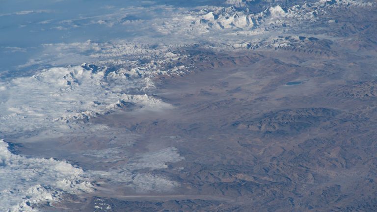
The Himalayan peaks are pictured in this oblique photograph from the International Space Station as it orbited 260 miles above central China on Feb. 8, 2023. Humans have taken over 4 million photographs from space. Crew photography can be used to study changes on Earth’s surface over time as well as significant weather events. See more images from the Space Station. Image Credit: NASA 2023年2月8日,当国际空间站在中国中部上空260英里的轨道上运行时,这张倾斜的照片拍摄了喜马拉雅山的山峰。 人类已经从太空拍摄了400多万张照片。宇航员摄影可用于研究地球表面随时间的变化以及重大天气事件。查看更多来自空间站的图片。 影像来源:NASA

国际空间站访问南帕德雷岛

国际空间站访问南帕德雷岛

While the International Space Station orbited over the Gulf of Mexico on Sept. 19, 2022, NASA astronaut Bob Hines captured this image of South Padre Island, a barrier island along the coast of Texas. The island is part of the greater Padre Island, the longest barrier island in the world, which spans a length of 113 miles (182 kilometers). Barrier islands along the Gulf and East coasts of North America play a critical role protecting the mainland from the damaging effects of storms. They bear the brunt of large storm surges and reduce flooding on the mainland. Image Credit: NASA/Bob Hines 当国际空间站于2022年9月19日在墨西哥湾上空飞行时,NASA宇航员鲍勃·海恩斯拍摄了这张南帕德雷岛的照片,这是德克萨斯州海岸的一个屏障岛。该岛是世界上最长的堰洲岛——帕德雷岛的一部分,全长113英里(182公里)。 沿墨西哥湾和北美东海岸的堰洲岛在保护大陆免受风暴的破坏性影响方面发挥着关键作用。它们承受着大型风暴潮的冲击,减少了大陆的洪水。 影像来源:NASA/Bob Hines

鹰巢

鹰巢

An American bald eagle occupies a nest near Kennedy Parkway North at NASA’s Kennedy Space Center on Feb. 8, 2023. Each year, eagles take up winter residence at the Florida spaceport, breeding and raising a new generation. The center shares a boundary with the Merritt Island National Wildlife Refuge, home to more than 1,500 species of plants and animals, and 15 federally listed species. Image Credit: NASA/Ben Smegelsky 2023年2月8日,NASA肯尼迪航天中心肯尼迪大道北附近,一只美国秃鹰在肯尼迪公园北附近的一个鸟巢里筑巢。每年,老鹰都会在佛罗里达太空港过冬,繁殖和养育新一代。肯尼迪航天中心与梅里特岛国家野生动物保护区共享边界,梅里特岛是1500多种动植物和15种联邦政府列名物种的家园。 影像来源:NASA/Ben Smegelsky

参观NISAR

参观NISAR

Officials from NASA, the Indian Space Research Organisation (ISRO), and the Indian Embassy visit a clean room at NASA’s Jet Propulsion Laboratory on Feb. 3, 2023, to view the scientific instrument payload for the NASA-ISRO Synthetic Aperture Radar (NISAR) mission. The NISAR mission—a joint effort between NASA and ISRO—will measure changes to Earth’s land ice surfaces down to fractions of an inch. Data collected by this satellite will help researchers monitor a wide range of changes critical to life on Earth in unprecedented detail. Learn more about the visit and what NISAR will do. Image Credit: NASA/JPL-Caltech 2023年2月3日,NASA、印度太空研究组织(ISRO)和印度大使馆的官员参观了NASA喷气推进实验室的一间洁净室,以查看NASA-ISRO合成孔径雷达(NISAR)任务的科学仪器有效载荷。 NASA和ISRO联合开展的NISAR任务将测量地球陆地冰层表面的变化,精确到一英寸。这颗卫星收集的数据将帮助研究人员以前所未有的细节监测对地球生命至关重要的广泛变化。 了解关于这次访问和NISAR将做什么的更多信息。 图片来源: NASA/JPL-Caltech