巴西的新月形沙丘

巴西的新月形沙丘

Former NASA astronaut Jack Fischer captured this photograph of Lagoa dos Barros and crescent-shaped barchan dunes on the Atlantic coastline of southern Brazil on July 9, 2017, while aboard the International Space Station. Barchan dunes are sand dunes that form in areas with one wind direction and little vegetation. In this case, fierce winds from the Western Atlantic sculpt the sand along the coast into distinctive crescent shapes. The tips of barchan dunes point downwind, showing the prevailing wind direction. These fragile formations act as barriers keeping the wind and waves from penetrating inland, blunting the effect of storms and minimizing coastal erosion. See more photos of Earth taken from space. Image Credit: NASA/ Jack Fischer 2017年7月9日,前NASA宇航员杰克·菲舍尔在国际空间站上拍摄了这张巴西南部大西洋海岸线上的拉戈亚·多斯·巴罗斯和新月形沙丘的照片。 新月形沙丘是在单一风向和植被稀少的地区形成的沙丘。在这种情况下,来自西大西洋的强风将海岸的沙子塑造成独特的新月形。新月形沙丘的尖端指向下风,表明盛行风向。这些脆弱的地层充当屏障,阻止风和海浪穿透到内陆,减弱风暴的影响,最大限度地减少海岸侵蚀。 查看更多从太空拍摄的地球照片。 图片来源: NASA/ Jack Fischer

用红树林稳定海岸线

用红树林稳定海岸线

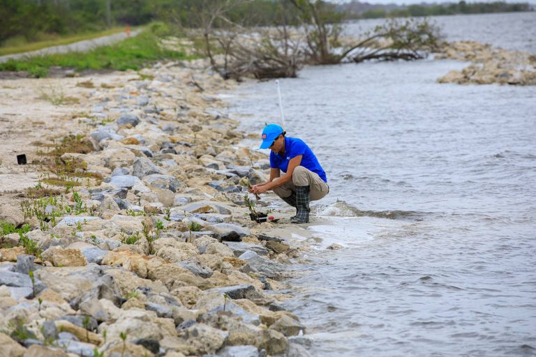
A team member from the Environmental Management Branch at NASA’s Kennedy Space Center works to remove a mangrove seedling deposited by tropical winds on the shoreline of KARS Park at Kennedy in this image from April 12, 2023. This spring, workers in the area replaced sand and finished an offshore wave break. The mangroves will be repotted and held in nearby surface water protected from wind, waves, and ongoing maintenance activities until they can be replanted along the shoreline later. With its 140,000 acres located along the Atlantic coastline and within the Indian River Lagoon estuary, Kennedy has long taken measures to ensure its shorelines remain resilient. Mangroves are one of the greatest allies against erosion, as their root structure protects the shoreline in addition…

暴雨和大雪使图莱里湖恢复生机

暴雨和大雪使图莱里湖恢复生机

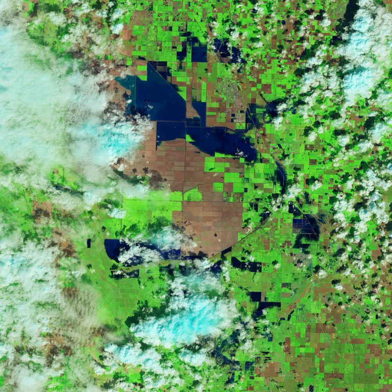
Floodwater (dark blue) stands out against the vegetation in agricultural fields around Tulare Lake near Corcoran, California, in this enhanced color image taken by Landsat 8 on March 29, 2023. Heavy rain and snow in the first three months of 2023 have once again brought water to Tulare’s lakebed, but also flooding several nearby towns. 2023 has been the wettest year in the region’s history. Tulare Lake, in California’s San Joaquin Valley, was once the largest freshwater lake west of the Mississippi River. By 1920, the rivers that fed the lake were dammed and diverted for uses such as irrigation. Since then, the lakebed has been covered with farms that grow a variety of crops. See what the region looked like in March 2022. Image…

路易斯安那州的稻田

路易斯安那州的稻田

This Feb 3, 2023, enhanced-color image from Landsat 9 highlights a green and blue patchwork pattern in flooded rice fields in southwestern Louisiana. Raised levees used for water management form the grid pattern between the fields, which appear dark blue. As it flowed through several southern states over tens of thousands of years, the Mississippi River left a valuable layer of fertile soil in its wake. This low-lying floodplain and the flat coastal prairies of Louisiana and Texas are now home to most of the rice farms in the United States. In 2021, Arkansas, Louisiana, Mississippi, and Texas—collectively known as the Rice Belt—produced about 73 percent of all rice in the United States. Image Credit: NASA 这张2023年2月3日的增强彩色图像来自陆地卫星9号,突出显示了路易斯安那州西南部被洪水淹没的稻田中绿蓝相间的图案。用于水管理的加高的堤坝形成了田地之间的网格图案,呈现深蓝色。 数万年来,密西西比河流经美国南部几个州,留下了一层宝贵的沃土。这片低洼的洪泛平原以及路易斯安那州和德克萨斯州平坦的沿海大草原现在是美国大部分水稻农场的所在地。2021年,阿肯色州、路易斯安那州、密西西比州和德克萨斯州(统称为水稻带)的水稻产量约占美国总产量的73%。 影像来源:NASA

颜色爆炸; 美丽的地球

颜色爆炸; 美丽的地球

This image, captured by the Landsat 8 satellite, shows the view over Western Australia on May 12, 2013. The image shows rich sediment and nutrient patterns in a tropical estuary area and complex patterns and conditions in vegetated areas. 这张由地球资源卫星8号拍摄的图像显示了2013年5月12日澳大利亚西部的景色。该图像显示了热带河口地区丰富的沉积物和养分模式以及植被区的复杂模式和条件。 The image is enhanced and involved masking, separately enhancing and then reassembling water and land portions of the image. The water patterns are the result of an RGB display of Landsat-8’s red, blue, and ultra-blue bands. Land is shown using short-wavelength-infrared, near-infrared and green. 对图像进行增强和掩蔽,分别增强图像的水和陆地部分,然后重新组合图像。这些水纹是陆地卫星8号的红色、蓝色和超蓝色波段的RGB显示结果。土地使用短波红外、近红外和绿色显示。 Image Credit: NASA/USGS Landsat; Geoscience Australia 影像来源:NASA/USGS Landsat; Geoscience Australia

2021年度灾难:回顾

2021年度灾难:回顾

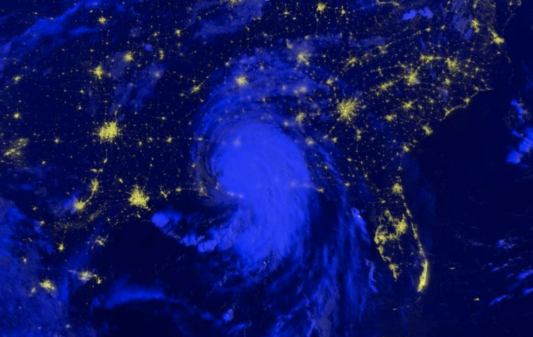
In 2021, Hurricane Ida left over 1 million people without power, tornadoes tore across the American Midwest, volcanoes forced people to evacuate their homes, wildfires covered the American West and unusual flooding wreaked havoc on Central Europe. 2021年,飓风艾达导致100多万人断电,龙卷风席卷美国中西部,火山爆发迫使人们撤离家园,野火覆盖美国西部,罕见的洪水对中欧造成严重破坏。 Some characteristics of natural hazards, such as hurricanes, floods and wildfires, have been historically predictable and have informed disaster preparation. However, with human emissions of greenhouse gases increasing Earth’s temperature, we’re seeing changes in those characteristics: wildfire and drought seasons are lengthening, hurricanes and rainfall are becoming more intense, and coastal flooding is increasing. 自然灾害的一些特征,如飓风、洪水和野火,在历史上是可以预测,并为备灾提供了信息。然而,随着人类排放的温室气体使地球温度升高,我们正在看到这些特征的变化:野火和干旱季节正在延长,飓风和降雨变得更加强烈,沿海洪水也正在增加。 By sponsoring application science and fostering domestic and international partnerships, the NASA Disasters program seeks to use its Earth observation data to enable disaster-resilient communities in a changing climate. 通过资助应用科学和培育国内和国际伙伴关系,NASA灾难项目寻求利用其地球观测数据,使社区能够在不断变化的气候中抵御灾害。 For details…

NASA启动新任务以监测地球景观

NASA启动新任务以监测地球景观

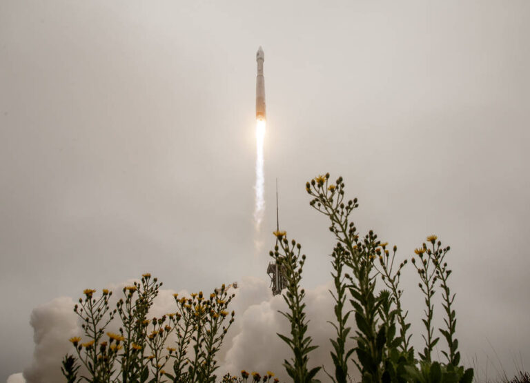
2021年9月27日星期一,联合发射联盟(ULA)的阿特拉斯五号火箭携带地球资源卫星9号从加利福尼亚州范登堡空军基地的3号航天发射场发射。地球资源卫星9号是美国国家航空航天局/美国地质调查局的一项联合任务,它将延续监测地球陆地和沿海地区的传统。 影像来源:美国国家航空航天局/比尔·英格尔斯 美国国家航空航天局(NASA)为监测地球陆地表面而建造的地球资源卫星9号,于美国东部时间星期一下午2点12分从加利福尼亚州范登堡空军基地成功发射。 作为与美国地质调查局(USGS)的一项联合任务,地球资源卫星9号由联合发射联盟的宇宙神Ⅴ号火箭从范登堡航天发射场3E升空。挪威的斯瓦尔巴群岛卫星监测地面站在发射后约83分钟获得了航天器的信号。地球资源卫星9号在到达其最终轨道高度438英里(705公里)时的性能与预期相符。 “NASA利用我们自己前所未有的舰队的独特资产,以及其他国家的仪器,来研究我们自己的星球及其气候系统。”MASA局长比尔·纳尔逊(Bill Nelson)说:“有了50年的数据库作为基础,地球资源卫星9号将把这个历史性的、无价的全球项目提升到新的水平。我们期待在Landsat Next上再次与美国地质调查局和内政部的合作伙伴合作,因为我们从未停止推进我们的工作,以了解我们的地球。” “今天的成功发射是美国地质调查局和NASA之间近50年的联合伙伴关系中的一个重要里程碑,几十年来,他们一直合作收集宝贵的科学信息,并利用这些数据以最大的科学完整性来制定政策,”内政部长德布·哈兰德(Deb Haaland)说。“随着气候危机的影响在美国和全球的加剧,地球资源卫星9号将提供数据和图像,以帮助在关键问题上做出基于科学的决定,包括水的使用、野火的影响、珊瑚礁的退化、冰川和冰架的退缩以及热带森林的破坏。” 第一颗地球资源卫星于1972年发射。从那时起,NASA一直在轨道上保持一颗地球资源卫星,以收集覆盖我们星球表面的物质和土地使用变化的图像。这些图像使研究人员能够监测各种现象,包括农业生产力、森林范围和健康、水质、珊瑚礁生境健康和冰川动态。 “地球资源卫星任务是独一无二的,”NASA华盛顿总部地球科学部主任卡伦·圣日尔曼(Karen St. Germain)说。“近50年来,地球资源卫星对我们的地球进行了观察,提供了从几天到几十年的时间尺度上地球表面变化的无与伦比的记录。通过与美国地质调查局的合作,我们已经能够为从农民到资源管理者和科学家等用户提供连续、及时的数据。这些数据可以帮助我们在不断变化的气候中了解、预测和规划未来变化的气候。” 地球资源卫星9号和它的姊妹卫星地球资源卫星8号一起进入轨道。这两颗卫星将协同工作,每8天收集一次整个地球的图像。 NASA负责科学的副局长托马斯·泽布亨(Thomas Zurbuchen)表示:“在观测我们这颗不断变化的地球时,地球资源卫星9号将成为我们天空中新的眼睛。”他说:“通过与其他陆地资源卫星以及运营哨兵-2号卫星的欧洲航天局合作伙伴协同工作,我们将获得比以往更全面的地球观测。通过这些卫星在轨道上共同工作,我们将每两天对我们星球上的任何地方进行观测。这对于跟踪作物生长和帮助决策者监控地球及其自然资源的整体健康状况非常重要。” 地球资源卫星9号上的仪器——陆地成像仪2号(OLI-2)和热红外传感器2号(TIRS-2)——测量地球表面反射或辐射的11种波长的光,包括可见光谱以及我们肉眼无法探测到的其他波长。随着卫星的运行,这些仪器将捕捉到115英里(185公里)范围内的图像。这些图像中的每个像素代表一个大约98英尺(30米)宽的区域,大约相当于一个棒球内场的大小。在这么高的分辨率下,资源管理者将能够识别美国大部分的农田。 “发射总是令人兴奋的,今天也不例外,”NASA地球资源卫星9号项目科学家杰夫·马塞克( Jeff Masek)说。“但对我来说,作为一名科学家,最好的部分将是当卫星开始提供人们所期待的数据时,为地球资源卫星在数据用户群体中的传奇声誉添砖加瓦。” 位于南达科他州苏福尔斯的美国地质调查局地球资源观测与科学(EROS)中心负责处理和存储来自仪器的数据,并将这些信息不断添加到所有地球资源卫星50年的数据中。 所有的地球资源卫星图像和嵌入的数据都是免费和公开的,这一政策自2008年开始以来,已经有超过1亿次的下载。 NASA负责管理地球资源卫星9号任务。位于马里兰州格林贝尔特的NASA戈达德太空飞行中心的团队也建造并测试了TIRS-2仪器。位于佛罗里达州肯尼迪航天中心的NASA发射服务项目负责管理该任务的发射。EROS将执行任务并管理地面系统,包括维护地球资源卫星档案。位于科罗拉多州博尔德的Ball Aerospace公司建造并测试了OLI-2仪器。联合发射联盟是地球资源卫星9号发射的火箭供应商。位于亚利桑那州吉尔伯特的诺斯罗普·格鲁曼公司建造了地球资源卫星9号航天器,将其与仪器整合在一起并进行了测试。 如欲了解关于地球资源卫星9号的更多信息,请访问: https://www.nasa.gov/landsat9 参考来源: https://www.nasa.gov/press-release/nasa-launches-new-mission-to-monitor-earth-s-landscapes

Landsat 9号卫星就位进行封装

Landsat 9号卫星就位进行封装

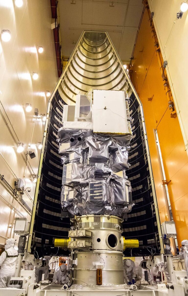
Inside the Integrated Processing Facility at Vandenberg Space Force Base in California, the Landsat 9 spacecraft is moved into position for encapsulation on Aug. 16, 2021. The two halves of the United Launch Alliance (ULA) payload fairing will surround and encase Landsat 9 to protect it during launch atop the ULA Atlas V rocket. Landsat 9 will launch on the Atlas V rocket from Space Launch Complex 3 at Vandenberg in September of this year. The launch is being managed by NASA’s Launch Services Program based at Kennedy Space Center, America’s multi-user spaceport. The Landsat 9 satellite, managed by the agency’s Goddard Space Flight Center in Greenbelt, Maryland, will continue the nearly 50-year legacy of previous Landsat missions. It will monitor key natural and economic…