来自波波卡特佩特火山的羽流

来自波波卡特佩特火山的羽流

Popocatépetl, one of Mexico’s most active volcanoes, has been erupting since 2005. On April 14, 2023, when this image was acquired by Landsat 8, monitoring systems detected water vapor, volcanic gases, and ash coming from the volcano. Plumes rose as high as 4.5 miles (7.3 kilometers). Learn more about Popocatépetl. Image Credit: NASA/Lauren Dauphin; USGS 波波卡特佩特尔火山是墨西哥最活跃的火山之一,自2005年以来一直在喷发。2023年4月14日,当地球资源卫星8号获取这张图像时,监测系统检测到了来自火山的水蒸气、火山气体和火山灰。羽流高达4.5英里(7.3公里)。 了解关于波波卡特佩特火山的更多信息。 影像来源:NASA/Lauren Dauphin; USGS

暴雨和大雪使图莱里湖恢复生机

暴雨和大雪使图莱里湖恢复生机

Floodwater (dark blue) stands out against the vegetation in agricultural fields around Tulare Lake near Corcoran, California, in this enhanced color image taken by Landsat 8 on March 29, 2023. Heavy rain and snow in the first three months of 2023 have once again brought water to Tulare’s lakebed, but also flooding several nearby towns. 2023 has been the wettest year in the region’s history. Tulare Lake, in California’s San Joaquin Valley, was once the largest freshwater lake west of the Mississippi River. By 1920, the rivers that fed the lake were dammed and diverted for uses such as irrigation. Since then, the lakebed has been covered with farms that grow a variety of crops. See what the region looked like in March 2022. Image…

颜色爆炸; 美丽的地球

颜色爆炸; 美丽的地球

This image, captured by the Landsat 8 satellite, shows the view over Western Australia on May 12, 2013. The image shows rich sediment and nutrient patterns in a tropical estuary area and complex patterns and conditions in vegetated areas. 这张由地球资源卫星8号拍摄的图像显示了2013年5月12日澳大利亚西部的景色。该图像显示了热带河口地区丰富的沉积物和养分模式以及植被区的复杂模式和条件。 The image is enhanced and involved masking, separately enhancing and then reassembling water and land portions of the image. The water patterns are the result of an RGB display of Landsat-8’s red, blue, and ultra-blue bands. Land is shown using short-wavelength-infrared, near-infrared and green. 对图像进行增强和掩蔽,分别增强图像的水和陆地部分,然后重新组合图像。这些水纹是陆地卫星8号的红色、蓝色和超蓝色波段的RGB显示结果。土地使用短波红外、近红外和绿色显示。 Image Credit: NASA/USGS Landsat; Geoscience Australia 影像来源:NASA/USGS Landsat; Geoscience Australia

2021年度灾难:回顾

2021年度灾难:回顾

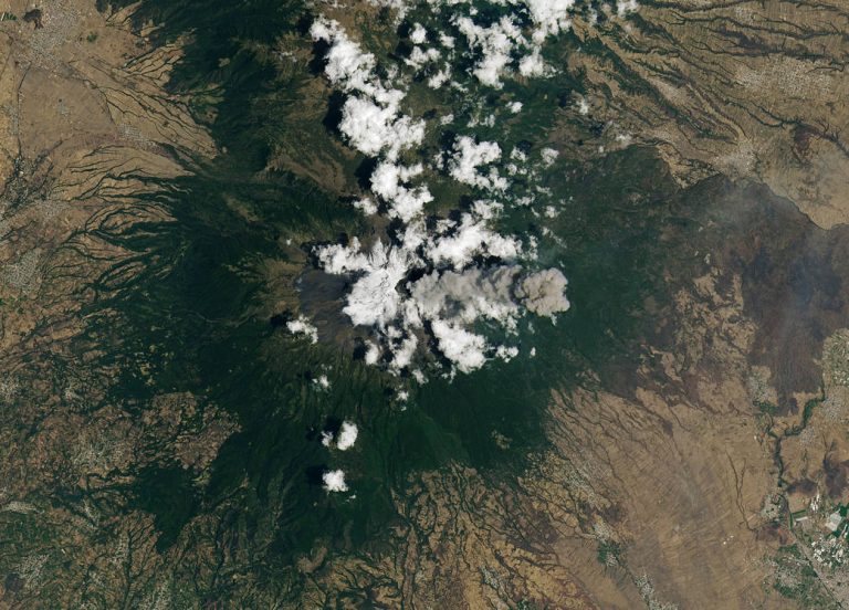
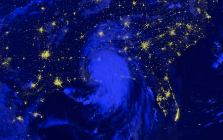
In 2021, Hurricane Ida left over 1 million people without power, tornadoes tore across the American Midwest, volcanoes forced people to evacuate their homes, wildfires covered the American West and unusual flooding wreaked havoc on Central Europe. 2021年,飓风艾达导致100多万人断电,龙卷风席卷美国中西部,火山爆发迫使人们撤离家园,野火覆盖美国西部,罕见的洪水对中欧造成严重破坏。 Some characteristics of natural hazards, such as hurricanes, floods and wildfires, have been historically predictable and have informed disaster preparation. However, with human emissions of greenhouse gases increasing Earth’s temperature, we’re seeing changes in those characteristics: wildfire and drought seasons are lengthening, hurricanes and rainfall are becoming more intense, and coastal flooding is increasing. 自然灾害的一些特征,如飓风、洪水和野火,在历史上是可以预测,并为备灾提供了信息。然而,随着人类排放的温室气体使地球温度升高,我们正在看到这些特征的变化:野火和干旱季节正在延长,飓风和降雨变得更加强烈,沿海洪水也正在增加。 By sponsoring application science and fostering domestic and international partnerships, the NASA Disasters program seeks to use its Earth observation data to enable disaster-resilient communities in a changing climate. 通过资助应用科学和培育国内和国际伙伴关系,NASA灾难项目寻求利用其地球观测数据,使社区能够在不断变化的气候中抵御灾害。 For details…