雪崩、冰爆和沙丘: NASA正在追踪火星上的新年
在地球上,新年往往伴随着冬日的奇幻美景,而火星北半球则经历着一种活跃甚至是“爆炸式”的春季解冻。当我们在地球迎接即将到来的跨年夜时,火星科学家已经抢先了一步:火星在2024年11月12日完成了绕太阳的一次公转。为此,一些研究人员为这个“火星新年”举杯庆祝。

在地球上,新年往往伴随着冬日的奇幻美景,而火星北半球则经历着一种活跃甚至是“爆炸式”的春季解冻。当我们在地球迎接即将到来的跨年夜时,火星科学家已经抢先了一步:火星在2024年11月12日完成了绕太阳的一次公转。为此,一些研究人员为这个“火星新年”举杯庆祝。

The Mars Reconnaissance Orbiter (MRO) captured this bit of ursine pareidolia on Dec. 12, 2022. While it resembles a bear we might see on Earth, this is actually a hill on Mars with a peculiar shape. A V-shaped collapse structure makes the nose, two craters form the eyes, and a circular fracture pattern shapes the head. The circular fracture pattern might be due to the settling of a deposit over a buried impact crater. Launched on August 12, 2015, the MRO studies the history of water on Mars and observes small-scale features on the planet’s surface. See more examples of pareidolia—the human tendency to see recognizable shapes in unfamiliar objects or data—from Mars. Image Credit: NASA/JPL-Caltech/University of Arizona 2022年12月12日,火星勘测轨道飞行器(MRO)于2022年12月12日拍摄了这张熊的幻想性视错觉。虽然它很像我们在地球上看到的熊,但这实际上是火星上一座形状奇特的小山。V形塌陷结构形成了鼻子,两个弹坑形成了眼睛,圆形断裂图案形成了头部。圆形断裂模式可能是由于沉积物在埋藏的撞击坑上沉降造成的。 MRO于2015年8月12日发射,研究火星上的水的历史,并观察火星表面的小尺度特征。请看更多关于空想的例子——人类倾向于在不熟悉的物体或数据中看到可识别的形状。 图片来源:NASA/JPL-Caltech/University of Arizona

This image taken by the Mars Reconnaissance Orbiter spacecraft’s HIRISE instrument on Oct. 23, 2022, of the northern plains of Arabia Terra shows craters that contain curious deposits with mysterious shapes and distribution. For instance, the deposits are located on the south sides of the craters, but not usually in the north, and are found only in craters larger than 600 meters in diameter. Scientists suspect that these features formed by sublimation of ice-rich material. Learn more about these crater deposits. Image Credit: NASA/JPL-Caltech/University of Arizona 2022年10月23日,这张由火星勘测轨道飞行器HIRISE仪器拍摄的阿拉伯半岛北部平原的照片显示,陨石坑中含有神秘形状和分布的奇怪沉积物。例如,这些沉积物通常位于陨石坑的南侧,而不在北侧,而且只在直径超过600米的陨石坑中发现。科学家怀疑这些特征是由富含冰的物质升华形成。 了解更多关于这些陨石坑沉积物的信息。 图片来源:NASA/JPL-Caltech/University of Arizona

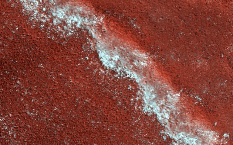
Though Mars is the Red Planet, false-color images can help us learn about its weather and geology. This image shows a variety of wind-related features on the Red Planet near the center of Gamboa Crater. Larger sand dunes form sinuous crests and individual domes. There are tiny ripples on the tops of the dunes, only several feet from crest-to-crest. These merge into larger mega-ripples about 30 feet apart that radiate outward from the dunes. The larger, brighter formations that are roughly parallel are called “Transverse Aeolian Ridges” (TAR). These TAR are covered with very coarse sand. The mega-ripples appear blue-green on one side of an enhanced color cutout while the TAR appear brighter blue on the other. This could be because the TAR are actively…

2021年02月27日 Perseverance Landing Site from Mars Reconnaissance Orbiter Image Credit: NASA/JPL-Caltech/MSSS Explanation: Seen from orbit a day after a dramatic arrival on the martian surface, the Perseverance landing site is identified in this high-resolution view from the Mars Reconnaissance Orbiter. The orbiter’s camera image also reveals the location of the Mars 2020 mission descent stage, heat shield, and parachute and back shell that delivered Perseverance to the surface of Mars. Each annotated inset box spans 200 meters (650 feet) across the floor of Jezero Crater. Perseverance is located at the center of the pattern created by rocket exhaust as the descent stage hovered and lowered the rover to the surface. Following the sky crane maneuver, the descent stage itself flew away to crash at a…
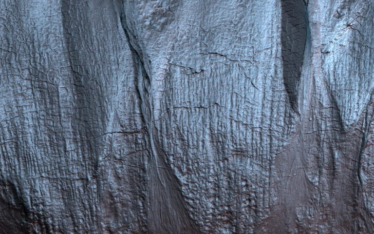
The Martian ice cap is like a cake with every layer telling a story. In this case, the story is one of climate change on Mars. This image of an exposed section of the north polar layered deposits (NPLD) looks much like a delicious slice of layered tiramisu. The NPLD is made up of water-ice and dust particles stacked one on top of the other. However, instead of icing, layers are topped with seasonal carbon dioxide frost, as seen here as lingering frost adhering to one of the layers. The high-resolution and color capabilities of the Mars Reconnaissance Orbiter’s HiRISE camera provides details on the variations in the layers. Scientists are also using radar data, which show us that they have continuity in the subsurface….

2020 March 1 A Hole in Mars Image Credit: NASA, JPL, U. Arizona Explanation: What created this unusual hole in Mars? The hole was discovered by chance in 2011 on images of the dusty slopes of Mars’ Pavonis Mons volcano taken by the HiRISE instrument aboard the robotic Mars Reconnaissance Orbiter currently circling Mars. The hole, shown in representative color, appears to be an opening to an underground cavern, partly illuminated on the image right. Analysis of this and follow-up images revealed the opening to be about 35 meters across, while the interior shadow angle indicates that the underlying cavern is roughly 20 meters deep. Why there is a circular crater surrounding this hole remains a topic of speculation, as is the full extent of…
Gullies on Mars form during the winter, fluidized by carbon dioxide frost, and scientists monitor sites on the planet for activity throughout the year. In this mid-winter scene, a Martian gully is almost completely frosted over the pole-facing slope within the shadow. The map is projected here at a scale of 50 centimeters (19.7 inches) per pixel. (The original image scale is 50.5 centimeters [19.9 inches] per pixel [with 2 x 2 binning]; objects on the order of 152 centimeters [59.8 inches] across are resolved.) North is up. NASA’s Mars Reconnaissance Orbiter, launched August 12, 2005, continuously monitors the Red Planet from orbit and continues in its mission to search for evidence that water persisted on the surface of Mars for a long period of…
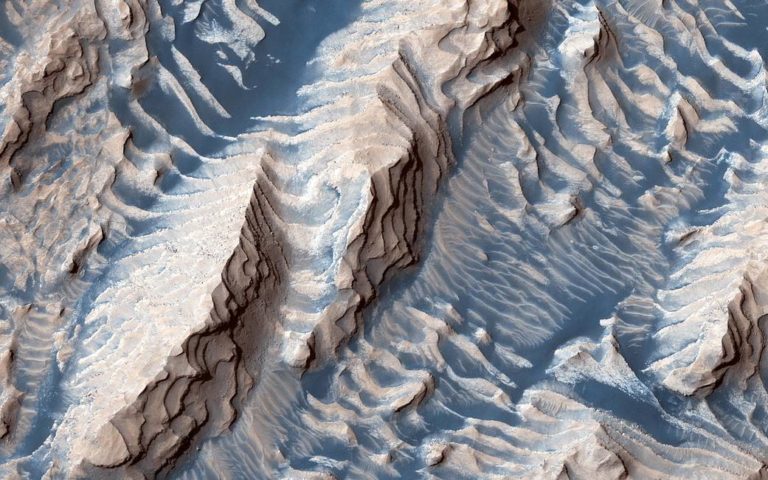
This image taken by the Mars Reconnaissance Orbiter spacecraft shows sedimentary rock and sand within Danielson Crater, an impact crater about 42 miles or 67 kilometers in diameter, located in the southwest Arabia Terra region of Mars. The rock was formed millions or billions of years ago when loose sediments settled into the crater, one layer at a time, and were later cemented in place. Cyclical variations in the sediment properties made some layers more resistant to erosion than others. After eons, these tougher layers protrude outward like stair steps. Across these steps, the winds have scattered sand (typically appearing darker and less red, i.e. “bluer” in contrast-enhanced color), giving rise to the zebra stripe-like patterns visible here. This image completes a stereo pair over…