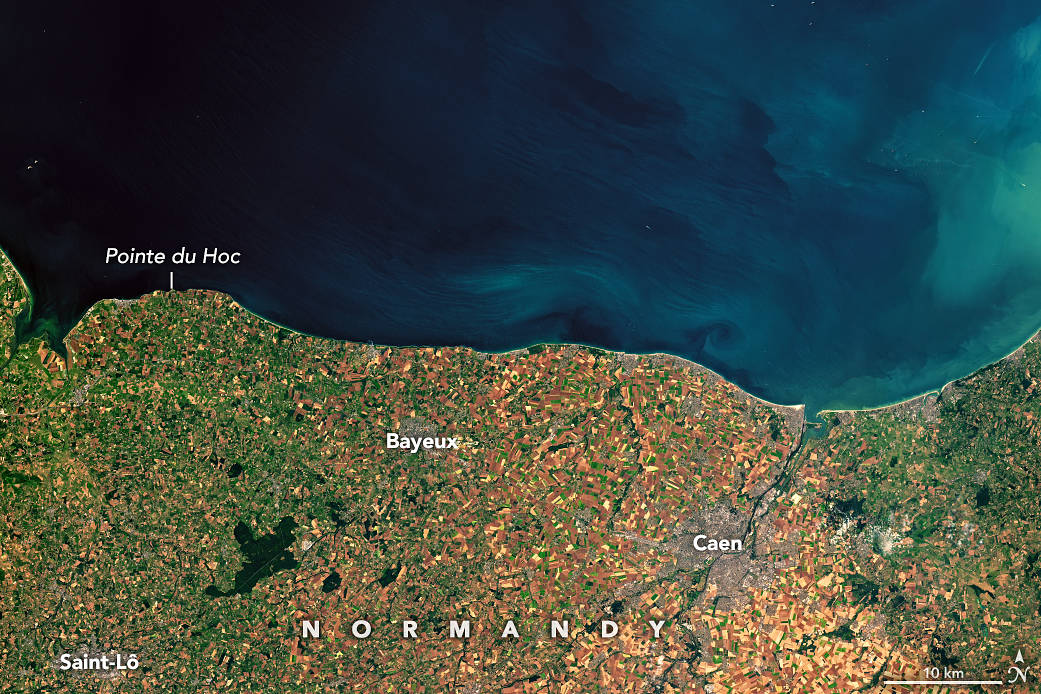
正是16万多名盟军士兵的无畏勇气,他们冲入了法国诺曼底80公里(50英里)重兵把守的海滩,使诺曼底登陆的胜利成为可能。但是,如果没有幕后工作的气象学家和地质学家的合理建议,人类历史上最重要的一场战斗可能会有截然不同的结果。
1944年6月4日,盟军的装甲部队要么集结在朴次茅斯港,要么开赴法国。盟军最高指挥官德怀特·艾森豪威尔将6月5日清晨定为两栖部队大规模登陆的日子,这是军事规划者精心挑选的日期。1944年6月的这三天,月亮足够亮,伞兵和飞行员可以有效地执行任务,潮水足够低,第一批登陆部队可以清除海滩上的地雷、带刺铁丝网和其他防御设施。
但他们也需要相对晴朗的天空和平静的大海。预测变化无常的英吉利海峡天气任务落到了来自美国陆军航空兵、英国皇家海军和英国气象局的气象学家们的肩上。当时,天气预报是一门新兴的科学;没有卫星,没有计算机预报模型,也没有气象雷达。
It was the raw courage of the more than 160,000 Allied troops who stormed an 80-kilometer (50-mile) stretch of heavily fortified beaches in Normandy, France, that made victory on D-Day possible. But without the sound advice of meteorologists and geologists working behind the scenes, one of the most consequential battles in human history could have gone quite differently.
On June 4, 1944, armadas of Allied forces were either amassed in Portsmouth Harbor or steaming toward France. Allied Supreme Commander Dwight Eisenhower had set the early morning of June 5 as the date for the massive amphibious invasion—a date military planners had carefully selected. It was one of just three days in June 1944 when the Moon would be bright enough for paratroopers and pilots to operate effectively and the tides would be low enough for the first landing parties to clear mines, barbed wire, and other defenses on the beaches.
But they also needed relatively clear skies and calm seas. The job of predicting the English Channel’s famously fickle weather fell to teams of meteorologists from the U.S. Army Air Corps, the British Royal Navy, and the British Meteorological Office. At the time, weather forecasting was a young science; there were no satellites, no computer forecast models, and no weather radar.
Credit: NASA Earth Observatory images by Joshua Stevens, using Landsat data from the U.S. Geological Survey. Story by Adam Voiland.



一场胜利决非偶然。